Weekend weather conditions were generally quiet across much of the area. However, on Saturday, an area of rain and storms set up across the coastal plains from Victoria, to just north of Bay City. A particularly heavy storm occurred across the northwestern part of Matagorda County, producing a rain total close to 6 inches at Midfield! The northern half of Matagorda County saw totals in the range of 0.5 to 1 inch. On Sunday, a strong to severe thunderstorm tracked southeast from Goldthwaite, to Fort Hood, Temple, and Cameron, producing totals of 0.5 to 1.5 inches.
As we kick off the new week, unseasonably warm temperatures will be the big weather news today and Tuesday. But a cold front moving through the area Tuesday night will bring noticeably cooler temperatures for the second half of the week and the upcoming weekend.
Forecasts continue to paint a wet and unsettled weather pattern for our region beginning Wednesday night, continuing through Saturday. Rain amounts over this period are predicted to total between 1 and 3 inches across the Hill Country and Central Texas regions, and between 2 and 4 inches across the coastal plains. See the section below for more details.
Monday Afternoon through Monday Night
Southerly breezes and scattered sunshine will combine to produce unseasonably warm and near-record temperatures this afternoon. Forecasts call for high temperatures to be in the low and mid-90s across the Hill Country and Central Texas regions, and around 88-90 degrees across the coastal plains.
Despite today’s sunny and hot weather, there will be a small window for isolated thunderstorm development across the eastern half of the Hill Country and the Interstate 35 corridor, including the Austin metro area. Forecasts call for the dry line to push east out of West Texas this afternoon, reaching the eastern Hill Country mid to late afternoon, and the I-35 corridor late afternoon to early evening. A weak wave of low pressure moving northeast across the region this afternoon may be strong enough to cause the development of isolated thunderstorms ahead of and along the dry line. The probability for thunderstorm development will only be 20 percent. But do note any storms which do happen to develop are expected to quickly become strong to severe. The primary severe weather threats will be large hail and damaging downburst winds.
The Storm Prediction Center has placed the eastern Hill Country and the Interstate 35 corridor under a Marginal Risk (a 1 out of 5 risk) for severe thunderstorms through Monday night.
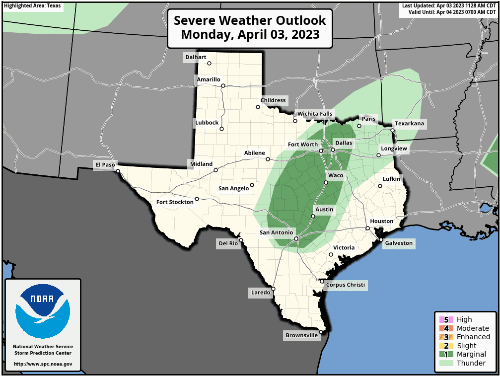
The threat for thunderstorms will come to an end late this evening as temperatures cool and the dry line moves back to the west.
Breezy conditions are forecast to develop late this afternoon and continue overnight. Expect southerly winds with speeds of 10-20 mph, and occasional gusts to 35 mph.
Tuesday through Wednesday Afternoon
Tuesday’s weather will feature a fair coverage of low clouds, breezy conditions, and warm temperatures. Highs are forecast to be near 88-90 degrees. Expect southerly breezes with gusts to 35 mph.
A Pacific cold front is forecast to push southeast across the region Tuesday night into Wednesday morning. The front is predicted to move off the middle Texas coast shortly after sunrise Wednesday, then pull up stationary. Atmospheric conditions are looking favorable for an area of rain showers and scattered thunderstorms to develop along behind the cold front when it moves across the area. The chance for rain will end across the Hill Country and Central Texas regions by about mid-morning Wednesday. Expect the sky to become partly cloudy. Meanwhile, a 40-50 percent chance for rain will continue across the coastal plains region through Wednesday afternoon.
Rain amounts Tuesday night through Wednesday afternoon are forecast to average around a quarter inch or less.
- Lows Wednesday morning will be in the low 50s across the Hill Country and Central Texas, and in the upper 60s across the coastal plains.
- High temperatures Wednesday are forecast to be in the low and mid-70s.
Wednesday Night through Saturday
A large trough of low pressure in the mid and upper atmosphere is forecast to set up across the southwestern U.S. Wednesday and remain nearly stationary through Saturday. A southwesterly wind flow developing along the eastern side of the trough is expected to pull warm air up and over the cooler air at the surface, resulting in widespread overrunning clouds and rain. In addition, forecasts call for several embedded waves of low pressure to track northeast across Texas out of Mexico, with each wave expected to enhance the development of rain. Just a slight chance for thunderstorms is forecast through the period and all thunderstorms should remain well below severe threshold.
The probability for rain will be around 60-70 percent beginning late Wednesday night, continuing through Saturday afternoon.
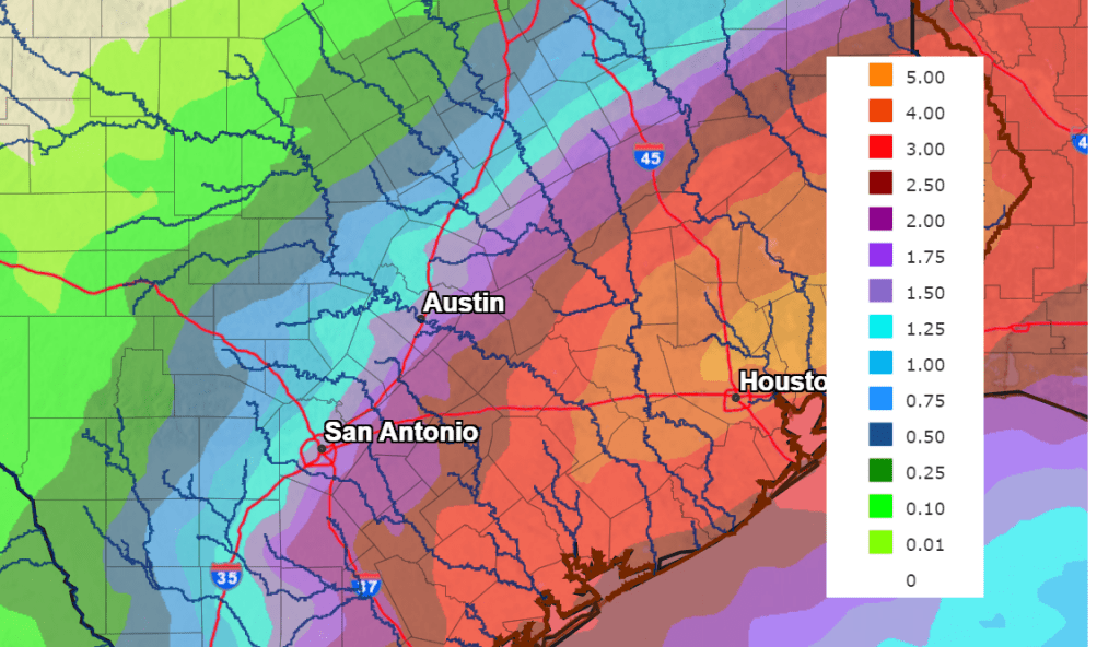
Based on how the overrunning pattern is forecast to setup, the highest totals of rain of rain are expected to occur mostly along and east of Interstate 35, with the lowest totals occurring across the Hill Country.
Rainfall forecasts through Saturday call for totals between 0.5 and 1 inch across the western half of the Hill Country, and between 1 and 1.5 inches across the eastern half. Across Central Texas, totals are forecast to be between 1 and 3 inches. Across the coastal plains, totals are forecast to be between 2 and 4 inches, with isolated totals to near 6 inches.
NWS Rainfall Forecast for the Period 7 pm Monday through 7 pm Next Monday:
- High temperatures Thursday through Saturday are forecast to be in the mid-60s to low 70s.
- Low temperatures Friday morning through Sunday morning are forecast to be in the mid-50s to low 60s.
Sunday through Next Monday
Forecasts call for the overrunning pattern to diminish as western trough lifts to the northeast. Expect a partly cloudy sky Sunday with just a slight chance for rain. This will be followed by a mostly sunny sky and dry weather next Monday. High temperatures are forecast to be in the low 80s.
The Full Pink Moon
The April Full Moon, also called the Full Pink Moon, will occur this Wednesday night, April 5th, at 11:34 pm CDT. This will be the first Full Moon of the 2023 spring season.
Have a good week.
Bob
Social Media