There will be a slight chance for scattered thunderstorms this afternoon for areas located to the east of Interstate 35. Sunday’s weather will bring a 30-40 percent chance for scattered rain showers and thunderstorms to the entire region. However, rain amounts look to only total around a quarter inch or less.
Unseasonably warm temperatures are predicted for Monday and Tuesday, with most areas expected to see low 90s.
The biggest weather news over the coming week will be the change to a wetter and more unsettled weather pattern beginning next Wednesday. A stalled out cold front over the region is expected to bring rounds of showers and thunderstorms Wednesday through Friday, with the possibility for the unsettled pattern to persist into next weekend. Forecasts suggest widespread totals of 1-3 inches between Wednesday and Friday, with the potential for even higher totals.
This Afternoon through Saturday
A strong storm system moving northeast across the Plains states will be helping to push a Pacific cold front into the Hill Country and Central Texas this afternoon. The cold front is predicted to move east-southeast across the Hill Country through early this afternoon, then slow down and pull up stationary somewhere along or just east of Interstate 35 mid to late afternoon. The atmosphere across the Hill Country and the I-35 corridor is expected to be too stable to allow for the development of thunderstorms along the front. However, for areas east of Interstate 35, from the middle Texas coast north to Bastrop, Giddings, and Rockdale, there will be a 20 percent chance for scattered thunderstorms through late afternoon. Totals, if any, should average less than a quarter inch.
Partly cloudy, breezy and weather can be expected this afternoon. For areas east of the cold front, look for south and southwesterly winds at 15-25 mph. For areas behind the cold, look for westerly winds with speeds of 15-20 mph. Wind speeds should decrease to 5-10 mph Friday evening and Friday night.
A mostly sunny sky will be in place Saturday as the weak cold front slowly sags south into the coastal plains.
- High temperatures Friday are forecast to generally be in the mid and upper 80s.
- Lows Saturday morning will include the upper 40s across the Hill Country, the low 50s across Central Texas, with low to mid-60s across the coastal plains.
- High temperatures Saturday will be in the low and mid-80s.
- Low temperatures Sunday morning will be in the mid and upper 50s across the Hill Country and Central Texas regions, and in the mid-60s across the coastal plains.
Sunday through Sunday Night
The stalled out cold front across the coastal plains is predicted to return north as a warm front Sunday morning, allowing warm and more humid air to spread back into Central Texas and the Hill Country. Meanwhile, a small trough of low pressure in the middle atmosphere is forecast to track to the east across northern Texas Sunday. This system is expected to tap into the warm and moist air near the surface and cause a 30-40 percent chance for scattered rain showers and thunderstorms across the region Sunday afternoon. Although not under an official severe weather risk, some of these thunderstorms could be strong to possibly severe. Primary threats will be large hail and damaging downburst winds. The chance for rain will diminish Sunday evening as the trough of low pressure exits to the northeast.
Expect a partly cloudy sky with breezy conditions Sunday afternoon. Look for southerly winds with speeds of 10-15 mph, and occasional gusts to 25 mph.
- High temperatures Sunday are forecast to be in the mid-80s.
- Lows Monday morning are predicted to be in the low and mid-60s, with lower 70s expected towards the coast.
Monday through Tuesday
An early taste of summer is forecast across the region both days as a large trough of low pressure moves across the southern Rockies, headed for the central Plains. This system will cause breezy south and southwesterly winds, and allow temperatures to soar into the 90s. Expect a mostly sunny sky on both days.
- High temperatures Monday and Tuesday are forecast to generally be in the low 90s across the Hill Country and Central Texas regions, and near 88-90 degrees across the costal plains.
- Lows Tuesday are forecast to be around 70 degrees.
Wednesday through Friday
A change to a wet and more unsettled weather pattern is predicted beginning Wednesday. Forecasts call for a weak Canadian cold front to push southeast across the area next Tuesday night into Wednesday morning, then pull up stationary just off the middle and upper Texas coast. There will be a chance for showers and thunderstorms along the cold front. Behind the cold front, a chance for rain showers and scattered thunderstorms is forecast to develop Wednesday and continue through Friday as waves of low pressure move across the region out of Mexico. Periods of moderate to occasionally heavy rain are forecast. In fact, many of the forecast solutions indicate this setup could bring our region significant totals of rain.
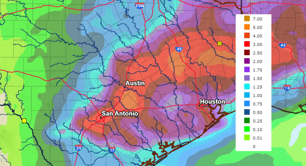
The National Weather Service’s rainfall outlook for the period between next Wednesday evening and next Friday evening calls for widespread totals of 1 to 3 inches, with isolated totals of 3 to 5 inches.
Being this rain event is several days away, the details are far from certain at this point. Note that some of the ensemble forecasts are pointing toward even higher totals. Stay tuned for further details in the coming days.
NWS Rainfall Forecast for the Period 7 pm Wednesday through 7 pm Friday:
Temperatures are forecast to trend cooler the second half of the week behind the cold front. Expect highs to be in the 70s, with lows in the 50s.
Interestingly, many forecast solutions indicate the wet pattern may extend through next weekend as a large trough of low pressure sinks into the Desert Southwest. Additional moderate rain will be possible
Have a good weekend!
Bob
Social Media