A cold front pushed across the area overnight, kicking up the wind and bringing with it a blast of cooler air. Under a mostly sunny sky, today’s temperature will be noticeably cooler, with highs ranging from the low 50s across the Hill Country, to the upper 50s near the coast. Expect strong north and northwesterly winds at 15-25 mph, with occasional gusts up to 35 through late afternoon. The gusty winds are forecast to decrease to a range of 10-15 mph Friday evening and Friday night.
A freeze is forecast for the Hill Country and much of Central Texas Friday night as wind speeds decrease. Lows Saturday morning are forecast to be near 28-30 degrees across the Hill Country, be around 30-32 degrees across Central Texas, and be in the mid-30s across the coastal plains.
The weekend weather is shaping to be quite nice as a weak ridge of high pressure spreads over the area. The sky is forecast to be sunny on Saturday and partly cloudy on Sunday. High temperatures are forecast to be in the mid and upper 50s Saturday, and in the low 60s Sunday. Lows Sunday morning will include the low 30s across the Hill Country, and in the middle 30s at most other locations.
A change in the weather will take place Sunday night into Monday when a trough of low pressure located over northern Baja, California begins to push east across northern Mexico. The approaching trough is predicted to pull considerable clouds north from the Gulf of Mexico. This will result in the development of a mostly cloudy sky across the area Sunday night through Monday. Lows Monday morning will be in the low 40s. High temperatures Monday are forecast to be mid-60s.
A chance for rain showers and even a few isolated thunderstorms is forecast to develop across the region Monday evening and Monday night as the trough moves into Far West Texas. The trough is forecast to track northeast across the Panhandle region Tuesday, exiting Texas by late Tuesday. The probability for rain is forecast to be around 70 percent Monday night and 40 percent Tuesday morning. But unlike the weather system earlier this week, the opportunity for rain from this next system is expected to be fairly short. The chance for rain is predicted to end from south to north Tuesday morning, followed by dry and sunny conditions Tuesday afternoon.
Rain amounts from the rain and isolated storms Monday night are not expected to be all that heavy. Forecasts call for most totals to average between 0.1 and 0.25 inches. Some isolated totals to around a half inch will be possible.
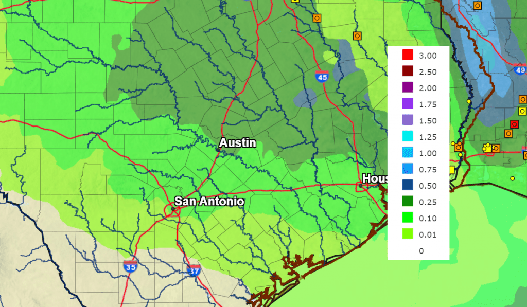
NWS Rain Forecast for the Period 6 pm Friday through 6 pm Wednesday:
Mostly sunny and dry weather is predicted Wednesday through Friday in the wake of Monday’s storm system. Temperatures are forecast to be mild Tuesday and Wednesday, with highs in the 70s. Lows Wednesday and Thursday mornings are forecast to be in the upper 40s to mid-50s.
Temperatures are forecast to trend cooler next Thursday and Friday following the passage of a Canadian cold front. No rain is forecast with the front. Expect a sunny sky. High temperatures both days are forecast to be in the mid-50s. Lows Friday and Saturday mornings are forecast to be in the upper 20s to low 30s across the Hill Country, in the low to mid-30s across Central Texas, and the mid to upper 30s towards the coast.
Partly cloudy and warmer weather is forecast next weekend as southerly breezes return. Expect highs in the 60s Saturday, and into the 70s on Sunday.
Forecasts call for a chance for rain to develop the following Monday (the 20th) as another trough of low pressure pushes east out of northern Mexico.
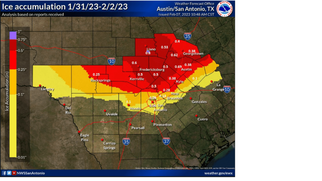
An Ice Accumulation Analysis from Last Week’s Ice Storm
The Austin/San Antonio office of the National Weather Service put together an analysis of ice accumulation from last week’s ice storm. This analysis was based on numerous reports on the ground and some ice accretion sensor data. It’s not perfect, but is a good guide to tell approximately how much ice accumulated and where. For some locations, this was the heaviest ice accumulation recorded in years, if not decades. (credit NWS Austin/San Antonio)
Have a good weekend.
Bob
Social Media