Last week’s ice storm and cold temperatures are now behind us as breezy south winds have brought inland significantly warmer air. These warmer readings will last into the middle of the week before cooler air makes a return to the area. Although a light freeze may develop across parts of the area Saturday morning, no widespread or prolonged freezes are predicted over the next two-week period.
Partly cloudy and breezy weather will be in place across Central and South Texas this afternoon in advance of a trough of low pressure tracking southeast out of the central and southern Rockies. Expect southerly breezes in the range of 10-20 mph, with gusts as high as 35 mph. High temperatures will be in the low and mid-70s across the Hill Country and Central Texas regions, and into the mid and upper 70s across the coastal plains.
With moisture increasing off the Gulf of Mexico, the sky looks to become cloudy beginning Tuesday evening. Lows Wednesday morning will range from the mid-50s across the Hill Country, to the low 60s across the coastal plains
The trough of low pressure over the Rockies is predicted to sink south to the Four Corners region Tuesday, then slowly lift northeast to the southern Plains states Tuesday night into Wednesday. With the approach of the upper trough, scattered rain showers are forecast to develop across the region Tuesday morning. This will be followed by a more widespread coverage of rain showers and even some isolated thunderstorms in the afternoon. The probability for rain will be near 60-70 percent.
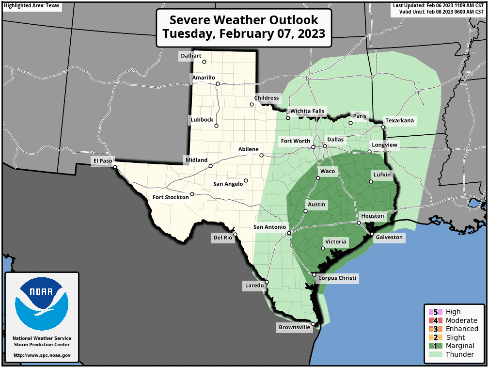
A good chance for rain showers and thunderstorms is forecast to take shape Tuesday night into Wednesday morning as a Pacific cold front associated with the trough pushes east across Texas. The front is predicted to slowly move across the Hill Country Tuesday evening and Tuesday night, reaching the Interstate 35 corridor around daybreak Wednesday, and pushing off the coast Wednesday afternoon. A few strong to marginally severe thunderstorms will be possible just ahead of and along the cold front Tuesday night through Wednesday morning. The greatest severe weather threat is expected to be strong, damaging winds. There will be a slight chance for large hail. The Storm Predicted Center has placed the eastern Hill Country along with all of Central and Southeast Texas under a Marginal Risk (a 1 out of 5 risk) for severe thunderstorms Tuesday afternoon through 6 am Wednesday morning.
The rain is forecast to taper off from west to east Wednesday morning into Wednesday afternoon as drier air spreads in behind the Pacific cold front.
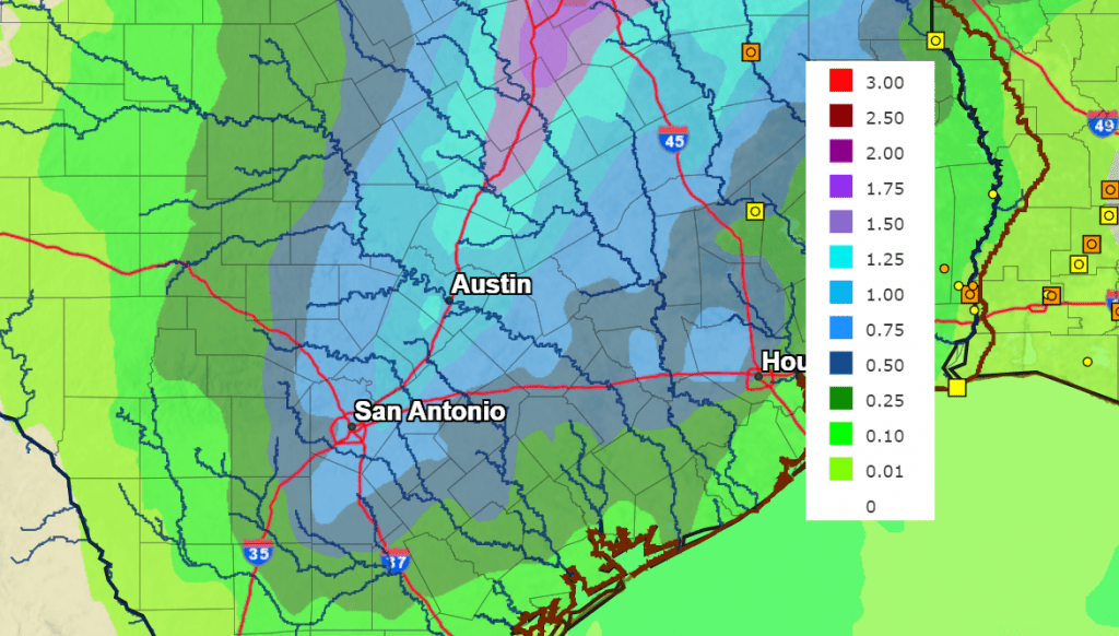
With very moist air spreading inland in advance of the approaching cold front and trough, nice totals of rain are forecast along with the potential for some locally heavy rain. Rain forecasts through Wednesday evening call for widespread totals of 0.75-1.5 inches across the central and eastern Hill Country along with most of Central Texas. Slightly lower totals are forecast across the western Hill Country and the coastal plains.
NWS Rainfall Forecast for the Period 6 pm Monday through 6 pm Wednesday:
Wednesday’s temperature is forecast to generally be in the 60s. Lows Thursday morning will generally be around 40-42 degrees.
A second, and deeper trough of low pressure is forecast to dive south across the Plains states Thursday that will help push a Canadian cold front south into Texas late Thursday. No rain is expected with the front, but the front will bring noticeably cooler air. A light freeze is forecast for the Hill Country and parts of Central Texas Saturday morning. The sky will be sunny Thursday through Friday.
- High temperatures Thursday will be in the mid and upper 60s.
- Lows Friday morning will range from the mid-30s across the Hill Country, to the low 40s across the coastal plains.
- High temperatures Friday are forecast to be in the mid-50s.
- Lows Saturday morning are forecast to be in the upper 20s across the Hill Country, the low 30s across Central Texas, and the mid-30s across the coastal plains.
Sunny weather is forecast Saturday, followed by a partly to mostly cloudy sky on Sunday. Expect high temperatures in the upper 50s to low 60s. Lows Sunday morning are forecast to be in the mid and upper 30s.
Another chance for rain showers is forecast across the region next Monday and Tuesday when a trough of low pressure tracks across Northwest Texas out of Mexico. As of now rain amounts are forecast to be in the range of 0.25 to 0.5 inches. Expect a cloudy sky both days, with high temperatures in the 60s to low 70s.
Mostly sunny and dry weather is predicted next Wednesday through Friday. High temperatures are forecast to be in the 60s to low 70s, with lows in the 40s.
Have a good week.
Bob
Social Media