This week’s winter storm is finally winding down. The arctic air that’s been in place since early in the week is finally modifying. The temperature went above freezing across the entire region late Thursday morning, allowing much of the ice to begin to melt. Forecasts indicate some very light rain showers will be possible across the Hill Country and the northern counties of Central Texas, including the Austin, through early Thursday evening. But with readings above freezing, no freezing is forecast. After that, no additional rain is expected as the slow-moving upper trough finally exits to the northeast.
The sky is predicted to gradually clear Thursday evening into Thursday night. This will allow the temperature to fall below freezing across the Hill Country and much of Central Texas for a few hours late Thursday night into early Friday morning. It`s possible some wet pavement could refreeze at a few spots, but widespread impacts to area roads and travel are not expected. Lows Friday morning will include the upper 20s across the Hill Country, the low 30s across Central Texas, and the upper 30s to 40 degrees across the coastal plains.
For the first time in a while, we have a quiet forecast for the next few days. A stable ridge of high pressure in the upper atmosphere is forecast to spread over Texas Friday, continuing through Monday, with the ridge causing sunny and warmer weather. An additional night of freezing temperatures is forecast Friday night. Lows Saturday morning will include the mid-20s across the Hill Country, the upper 20s across Central Texas, and the low to mid-30s across the coastal plains.
- High temperatures Friday will range from 50 degrees across the Hill Country, the mid-50s near the coast.
- High temperatures Saturday are forecast to be between 58 and 62 degrees.
- Lows Sunday morning will range from the upper 30s across the Hill Country, to the low 40s.
- High temperatures Sunday and Monday are forecast to be in the upper 60s to low 70s.
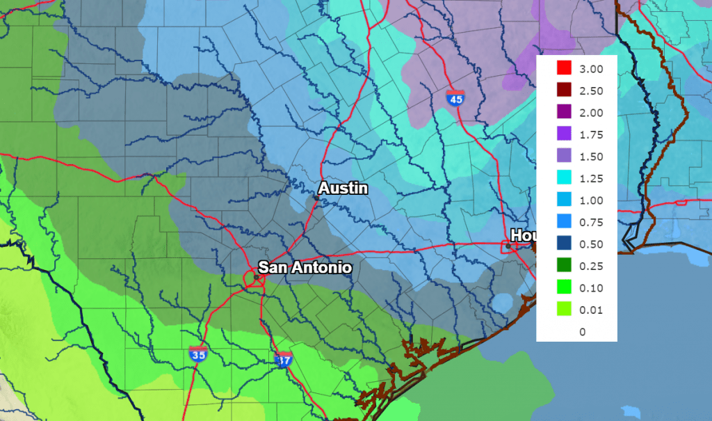
A chance for rain showers and scattered thunderstorms is forecast to develop next Tuesday through next Wednesday when a trough of low pressure dips southeast out of the southern Rockies and moves across northern Texas. The probability for rain will be near 40-50 percent. Rain amounts through the period are forecast to average between 0.5 and 0.75 inches across the Hill Country, and be between 0.5 and 1 inch at most other locations.
NWS Rain Forecast for the Period 6 pm Thursday through 6 pm Next Thursday:
Temperatures next week are forecast to be somewhat mild, with highs in the 60s and lows in the 40s. No freezing temperatures are expected.
Bob
Social Media