…A Winter Storm Warning is in Effect through 6 am Thursday for all of the Hill Country, plus Travis, Williamson, Bastrop, Hays, Lee, Comal, Caldwell, Fayette and Guadalupe Counties through 6 am Thursday…
…A Winter Weather Advisory is in Effect for Colorado and Austin Counties through noon Wednesday…
A hazardous winter weather event is underway across the Hill Country and a large part of Central Texas and it is expected to continue through Thursday morning. Overnight, light rain spread across the area resulting in widespread freezing rain and accumulating ice across the Hill Country and most of Central Texas. The ice has caused road conditions to become hazardous and at time treacherous—especially on elevated bridges and overpasses. Unfortunately the current cold and icy conditions won’t be going away anytime soon. Recent forecast solutions call for more freezing rain and accumulating ice Tuesday afternoon through Wednesday night as additional atmospheric disturbances move over our area.
This afternoon and evening, mainly light precipitation is forecast across the area. Expect little change in the temperature as the arctic air remains locked in place. Afternoon temperatures are forecast to hold in the mid and upper 20s across the Hill Country, the low 30s across Central Texas, and in the upper 30s to low 40s across the coastal plains. Ice accumulations up to a tenth of an inch are forecast.
Forecasts call for heavier and more significant rain to develop and spread northeast across our region beginning late Tuesday night, continuing through midday Wednesday as a wave of low pressure lifts northeast out of Mexico. This wave of rain is expected to bring additional accumulating ice to the warned area. With heavier rain expected, forecasts through midday Wednesday call for widespread ice accumulations of a quarter to a half inch, with some isolated three- quarter inch accumulations. Forecasts call for near-steady temperatures Tuesday night into Wednesday morning.
In the wake of the morning rain and freezing rain, intermittent light freezing precipitation is forecast across the area Wednesday afternoon and Wednesday evening. Little change in the temperature is forecast, so much of the precipitation is expected to remain frozen. Afternoon temperatures are forecast to be in the low 30s across the Country, the low and mid-30s across Central Texas, and upper 30s to 40 degrees across the coastal plains.
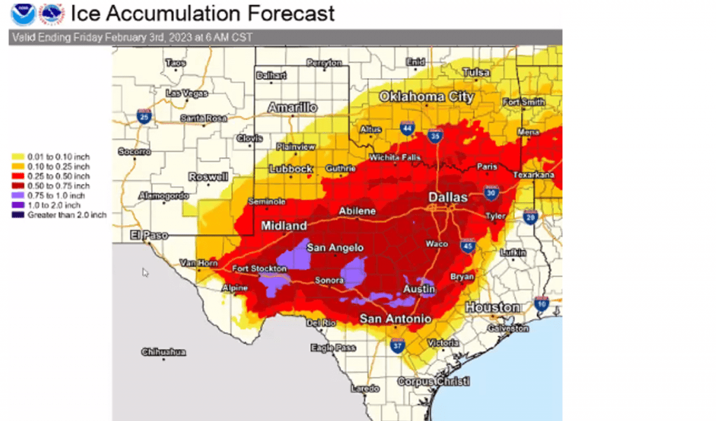
The forecast for ice accumulation through Thursday has increased from Monday’s prediction. The National Weather Service’s forecast now calls for widespread accumulations between 0.5 and 0.75 inches. Some isolated accumulations in excess of 0.75 inch will be possible.
NWS Ice Accumulation Forecast through 6 am Friday:
Slowly rising temperatures are forecast Wednesday night into Thursday morning. In fact, readings are forecast to rise above freezing across the Austin/Central Texas area and parts of the Hill Country after midnight Wednesday night. However, with considerable ice still in place, melting will not happen all that quickly. Lows Thursday morning are forecast to generally be in the mid-30s, with 40 degrees across the coastal plains. High temperatures Thursday afternoon are predicted to reach the mid-40s.
Meanwhile, rain showers and even some isolated thunderstorms are forecast to spread across the area late Wednesday night through Thursday morning as the final upper trough lifts northeast across Texas. Some light rain showers may linger through Thursday afternoon, but all of the rain should come to an end by Thursday evening. Rain amounts between Wednesday evening and Thursday evening are now forecast to generally average between a quarter and a half inch.
For Friday and the weekend, expect sunny and dry weather with high temperatures in the upper 50s to low 60s.
Bob
Social Media