A stagnant early fall weather pattern remains in place across Central Texas. Despite a weak cold front moving across the area Saturday, temperatures have remained very consistent, featuring warm afternoons and pleasant nights. No significant changes are expected through late week. It appears we will have to wait another week before we see a more noticeable drop in the temperature.
As we start off the new week, sunny conditions are in place across the eastern two-thirds of the state thanks to a weak ridge of high pressure over the area. It’s a different story across West Texas, where waves of low pressure moving north out of Mexico have sparked the development of scattered rain showers and thunderstorms. The activity has generally been occurring to the west of a line stretching from Del Rio, to San Angelo, to Wichita Falls. Periods of rain and isolated thunderstorms are forecast to continue across West Texas tonight through Tuesday morning. Meanwhile, sunny and dry weather looks to persist across the Hill Country, Central, and East Texas through Wednesday.
Forecasts continue to call for a weak cold front to sink south across our region Wednesday night into Thursday morning. Unfortunately, the chance for rain along the front has decreased from previous forecasts due to limited moisture and minimal convergence along front. While a couple of spotty rain showers will be possible with the front, most locations will likely stay dry. In advance of the front, southerly winds will bring increasing humidity levels Wednesday into Wednesday night. In addition, unseasonably warm temperatures look to develop on Wednesday.
- High temperatures this afternoon and Tuesday are forecast to be in the upper 80s across the Hill Country and coastal regions, and be around 90 degrees across Central Texas.
- High temperatures Wednesday are forecast to reach the low 90s across the Hill Country and coastal regions, and into the mid-90s across Central Texas.
- Lows Tuesday morning will generally be in the low 60s.
- Lows Wednesday morning will be in the mid and upper 60s.
Sunny weather is forecast Thursday through Friday. Drier and just slightly cooler air can be expected behind the cold front Thursday afternoon through Friday.
- High temperatures Thursday and Friday are forecast to be in the upper 80s.
- Lows Friday and Saturday mornings are predicted to range from around 58-60 degrees across the Hill Country, to the mid-60s across the Hill Country.
Mostly sunny weather is forecast Saturday. However, southerly winds will return in advance of another cold front sinking south through the Plains states. This front is shaping up to be a little stronger than the front expected Thursday. This next cold front is predicted to track south across our region Sunday afternoon through Sunday evening. Forecasts indicate conditions will be more somewhat favorable for the development of light rain showers along and just behind the cold front Sunday afternoon into Sunday night.
There are indications a somewhat better chance for rain showers and thunderstorms will also follow next Monday into Tuesday when a weak trough of low pressure over Mexico tracks to the northeast. Forecast solutions are currently indicating we could see totals in excess of a quarter inch. Sunny and dry weather looks to return for the second half of next week. Cooler temperatures will arrive behind the cold front beginning Sunday night.
High temperatures next week are predicted to be in the upper 70s to low 80s. Lows temperatures are predicted to be in the 50s.
Tropical Weather Outlook
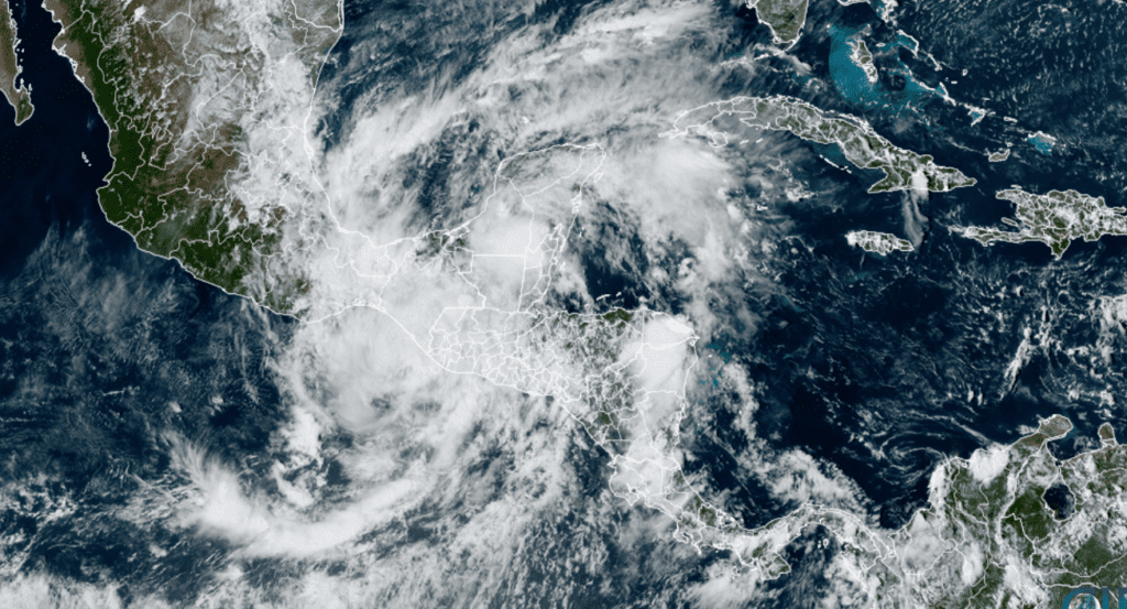
Tropical Storm Julia pushed west across Central America over the weekend. The system has since weakened to a tropical depression and is located over southern Guatemala. Maximum sustained winds have decreased to 35 mph. Julia is predicted to dissipate Monday evening. Julia is forecast to bring heavy rain to much of El Salvador, southern Guatemala, western Honduras, Nicaragua, and Belize through Tuesday.

NOAA/CIRA/RAMMB 10-10-2022 2:30 pm CDT
National Hurricane Center forecasters are monitoring a trough of low pressure located over the Yucatan Peninsula that is producing disorganized showers and thunderstorms. Some development of this system will be possible on Tuesday and Wednesday when the system moves slowly west-northwestward to northwestward over the far southwestern Gulf of Mexico. Increasing upper-level winds should prevent significant development late this week. NHC forecasters are giving this system just a 20 percent chance for development over the next 5 days. Moisture associated with this system is forecast to remain well to the south of Texas.
Elsewhere across the tropical Atlantic, conditions are quiet and tropical cyclone development is not expected for at least the next 5 days.
Bob


Social Media