Wednesday is looking like it will be the last of the widespread triple-digit temperatures for a while. Forecasts call for a high temperature of 98-103 degrees across the Hill Country and Central Texas regions, with upper 90s expected across the coastal plains. A couple of isolated showers will be possible south of Interstate 10, while the rest of the region should stay mostly sunny and dry.
Changes in the weather pattern will begin to take place early Thursday when a cold front sags south into the Hill Country and Central Texas. As of midday Wednesday, the front was located just south of the Red River, extending west to around Lubbock. The cold front is predicted to sink south to a position between Dallas and Waco this evening, sagging south to the northern Hill Country and the northern counties of Central Texas Thursday morning. The front is predicted to pull up stationary somewhere close to the Interstate 10 corridor Thursday evening.
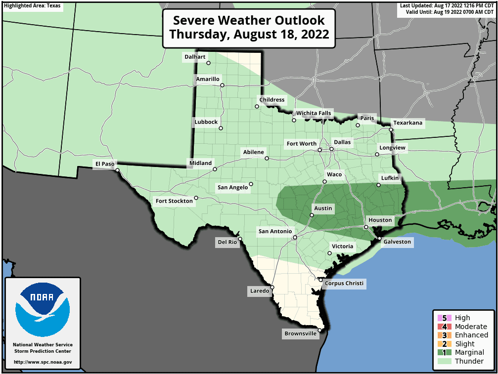
There will be a slight chance for scattered rain showers and thunderstorms across the region Thursday morning, with the chance for rain and storms increasing significantly by afternoon as the atmosphere becomes quite moist and fairly unstable. A widespread coverage of rain and thunderstorms is forecast, with the probability for rain around 50-60 percent. Some locally heavy downpours will be possible. In addition, some of the thunderstorms may become strong to possibly severe, producing strong and gusty winds. The Storm Prediction Center has placed the eastern Hill Country and all of Central Texas under a Marginal Risk (a 1 out of 5 risk) for severe thunderstorms through Thursday night.
Periods of rain showers and thunderstorms are forecast to continue across the region Thursday night through Friday as Thursday’s atmospheric setup remains in place. The rain is predicted to taper off Friday evening into Friday night as the weak front weakens and lifts back to the north.
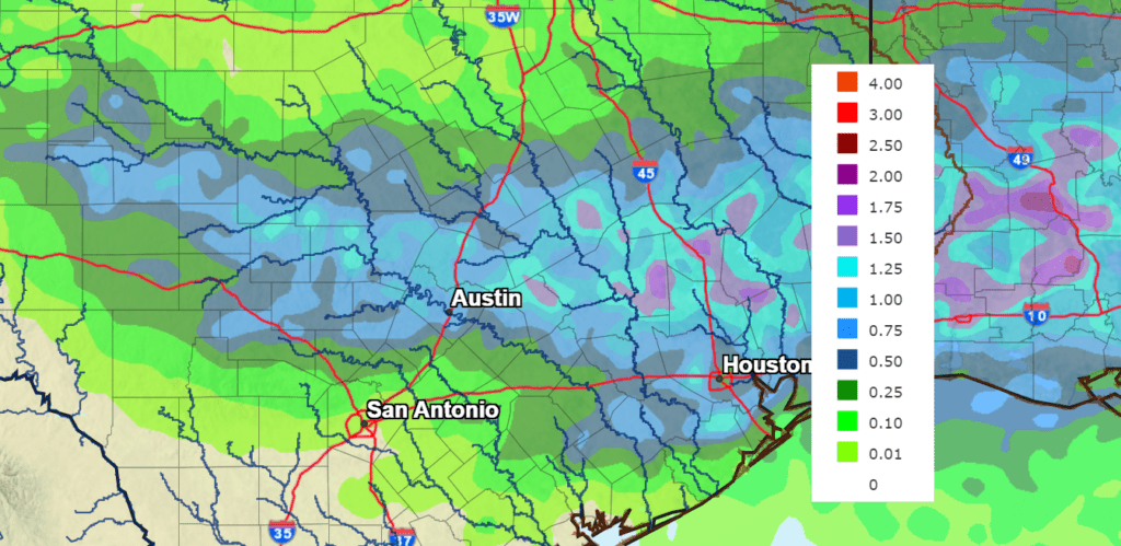
Very beneficial rains are expected over the next couple of days. The National Weather Service’s rainfall forecast calls for 2-day totals of 0.5-1 inches across the eastern Hill Country and most of Central Texas. Isolated heavier totals will be possible. Totals of 0.25-0.5 inches are forecast for the western Hill Country and the middle Texas coast.
NWS Rainfall Forecast for the Period 7 pm Wednesday through 7 pm Saturday:
Forecasts call for just a slight chance for scattered rain showers and thunderstorms across the Hill Country and Central Texas regions this weekend. Expect a partly cloudy sky with high temperatures in the mid and upper 90s. There may be a somewhat better chance for rain for the coastal region on Sunday as tropical moisture spreads up the coast.
The outlook for the first half of next week calls for more unsettled weather and a decent chance for rain as another cold front sinks south into the state, along with a surge of moisture off the Gulf of Mexico. There is even the possibility moisture from a tropical system could spread over our region, enhancing the chance for rain through the first half of next week. Rainfall forecasts for early next week show the possibility for significant rain.
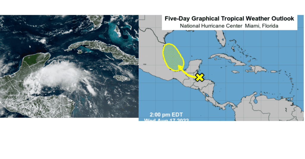
Monitoring a Tropical Wave in the Caribbean Sea
National Hurricane Center forecasters are closely monitoring a tropical wave located over the far southwestern Caribbean Sea. Satellite images show a large area of clouds and showers have recently developed in the waters just east of the Yucatan Peninsula. Surface observations do not indicate any sort of surface circulation at the current time. Forecasts call for the wave to move northwest across Central America later today and Thursday, then emerge over the Bay of Campeche Friday, where conditions seem somewhat favorable for an area of low pressure to develop. NHC forecasters are now giving this system a 30 percent chance for tropical development over the next 5 days.
The National Hurricane Center calls for this system to track northwest towards northeastern Mexico or southern Texas over the weekend. There is currently much uncertainty as to where this system will eventually move and it’s possible impacts on Texas. Next week’s cold front could cause this system to linger or slowly meander over some part of Texas into next week, posing the possibility for significant rain.
Stay tuned for additional details over the next few days as the forecast becomes a bit clearer.
Bob
Social Media