This summer’s heat wave continues, and unfortunately, there’s with no end in sight. July temperature has been averaging between 4 to 6 degrees above normal and readings have been among the hottest ever recorded for July. Temperatures month to date have averaged hotter than those recorded in July 2011.
A large and nearly stationary heat dome, or ridge of high pressure, continues to be the driving force behind the ongoing heat wave. Monday’s weather maps showed the heat dome covering most of the western and central U.S., with the center currently located over southern Colorado. Forecasts call for few changes in the position of the heat dome this week and through the upcoming weekend. As a result, expect a stagnant sunny, dry, and very hot weather pattern for the next several days. Temperatures do look to trend down about 2-3 degrees late week and through the weekend as the upper ridge weakens slightly. There are indications a weak Easterly Wave, or trough of low pressure will track west across the Gulf of Mexico this week, and arrive along the middle and lower coast on Friday. This system might bring a couple of isolated thunderstorms to parts of the lower coast Friday, but it is not expected to have any impact on the rest of the region.
- High temperatures Monday through Wednesday are predicted to be near 103-106 degrees across the Hill Country and Central Texas regions, and near 98-100 degrees across the coastal plains.
- High temperatures Thursday through Sunday are predicted to be near 100-103 degrees across the Hill Country and Central Texas regions, and be in the upper 90s across the coastal plains.
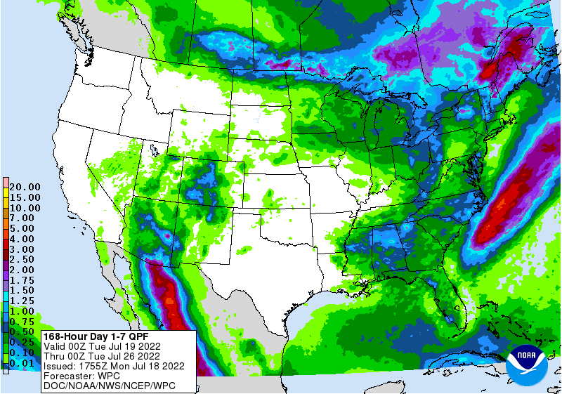
As mentioned above, no rain is forecast across Texas over the upcoming week. The National Weather Service’s 7-day rainfall forecast shows how Texas will bake and remain dry, while rain showers will occur to the west and east of Texas.
The outlook for next week calls for few changes as the heat dome/ridge of high pressure remains the main weather feature for Texas. The center of ridge is forecast to set up a little further to the west across Utah and Nevada, as opposed to Colorado and the Southern Plains this week. The ridge will cause continued sunny, dry, and very hot weather across our region. High temperatures are predicted to be around 100-103 degrees through the first half of the week, lowering to around 99-102 degrees late week and the following weekend. Similar conditions are forecast at the start of August.
Tropical Weather Outlook
Weather conditions remain quiet across the tropical Atlantic. There are no systems in place which pose a threat for tropical development over the next 5 days.
Have a good week.
Bob
Social Media