Sunny and very quiet weather is place across Texas as we close out the work week. A ridge of high pressure in the upper atmosphere situated over northwestern Mexico and the Southwestern U.S. is causing a dry and very stable atmosphere across Texas. Forecasts call for the ridge to spread east over Texas this weekend and Monday, keeping our weather sunny and dry. However, daytime temperatures will be trending noticeably warmer over the next few days, while nighttime readings will still be pleasantly cool. Light southwesterly breezes this afternoon will become southerly this weekend, pulling warmer air north from the Gulf region.
- High temperatures Friday are forecast to be in the mid-80s.
- Low temperatures Saturday morning will generally be in the upper 40s to low 50s.
- Lows Sunday morning will be in the low 50s.
- High temperatures Saturday and Sunday are forecast to be near 88-90 degrees across the Hill Country, in the upper 80s across Central Texas and in the low to mid 80s across the coastal plains.
- Lows Monday morning will be in the upper 50s.
- High temperatures Monday are forecast to be in the mid-50s.
Light winds are forecast Friday afternoon and Friday night. Wind speeds are predicted to increase to a range of 10-15 mph with gusts to 25 mph this weekend and Monday as the pressure gradient strengthens. The combination of these breezy conditions, combined with very dry air and considerable dry vegetation will cause elevated to near critical fire weather conditions across the entire region this weekend.
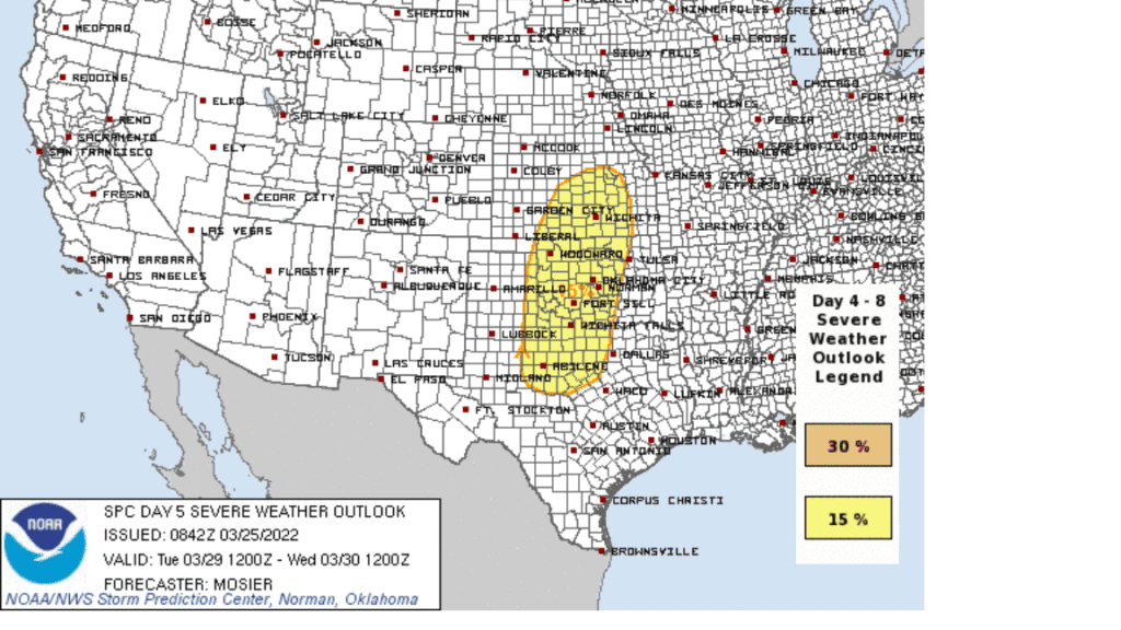
A change in the weather is predicted to take place next Tuesday into Wednesday. Forecasters are monitoring a trough of low pressure to the south of Alaska that is expected to push inland along the coast of California early next week. The trough is forecast track to the east-southeast, moving across the southern Plains, including northwestern Texas next Wednesday. This system is forecast to cause the development of strong to severe thunderstorms across Northwest Texas, extending south to Brownwood and Coleman. The atmospheric setup with this system is looking a little different from the setup we saw earlier this week in which severe storms and tornadoes developed across Central Texas. With this system, the threat for severe storms is predicted to be further north across Kansas, Oklahoma, and Northwestern Texas. The Storm Prediction Center’s Severe 5-day weather outlook shows a 15 percent chance for severe storms across the referenced area for Tuesday (mainly Tuesday night). Further south across the Hill Country and Central Texas regions, atmospheric dynamics are looking less impressive with this next system.
Clouds and moisture will increase off the Gulf in advance of this system Tuesday. This will likely result in Tuesday’s weather being partly to mostly cloudy and quite breezy. Expect a high temperature in the mid-80s.
Forecasts call for a Pacific cold front associated with the upper trough to push east across the state Tuesday night into Wednesday morning. An area of rain showers and thunderstorms is forecast to develop along and just behind the cold front. As mentioned earlier, the greatest threat for severe storms is expected to occur across Northwest Texas. The rain is forecast to end from west to east late Tuesday night into Wednesday morning. Rain amounts are not predicted to be very heavy, with most totals averaging close to a quarter inch.
Mostly sunny, breezy and slightly cooler weather will follow the cold front Wednesday afternoon. Expect a high temperature in the upper 70s to low 80s. Lows Thursday morning will range from the low 40s across the Hill Country to the low 50s towards the coast. Mostly sunny and dry weather is forecast for next Thursday and Friday. High temperatures will be around 80 degrees.
Looking out to next weekend, forecasts are calling for a slight chance for rain Saturday when a cold front spreads south through our area. Rain amounts are forecast to be quite low. This will be followed by another chance for rain Monday, April 4th, when a trough of low pressure spreads east across the southern Plains. High temperatures are forecast to remain around 80 degrees, with lows in the 50s.
Don’t Miss the Conjunction of Planets and the Moon this Weekend
In the early morning skies of March 27 and 28, 2022, you can catch a waning crescent moon passing a trio of planets. The planets are close together in what astronomers call a conjunction. Venus is the brightest planet, with two fainter planets near it, Saturn below and Mars to the west. On March 27, the moon will be approaching Mars on the sky’s dome. The moon that morning will be about the 25% illuminated, heading toward new moon on April 1.
But the view on March 28 is the real stunner. Then the moon, brilliant Venus, and fainter Mars and Saturn all bunch together within an 8-degree circle on the sky’s dome. Because it’s a waning moon, its phase will be even thinner than the morning before, only around 16% illuminated. The quartet will make for a beautiful photo op.
Have a great weekend!
Bob
Social Media