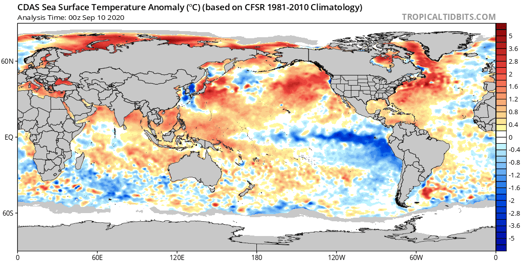
In an update issued Thursday, Climate Prediction Center forecasters indicated La Niña conditions officially developed in August. The latest sea surface temperature (SST) analysis shows a tongue of cooler-than-average waters extending across the central and eastern equatorial Pacific Ocean

Average sea surface temperature anomalies for 00z September 10, 2020.
In the last week, all Nino indices were negative, meaning sea surface temperatures were cooler than normal. The Nino-3.4 index came in at -0.9°C anomaly while the Nino-1+2 and Nino-3 index anomalies were more than -1.0°C anomaly.
Observations of subsurface waters along the equatorial region, between the coast of South America and the Date Line, showed these waters were also cooler than normal.
But one of the most factors establishing the La Niña involves the connection between the ocean and the atmosphere. A La Niña intensifies the contrast between the warm waters in the far western Pacific and the much cooler waters in the central and eastern Pacific waters. The connection involves a large-scale circulation pattern characterized by air rising over the very warm waters of the far western Pacific and Indonesia that travels eastward high in the atmosphere and sinks over the eastern Pacific. The air then travels back westward near the surface, increasing the easterly trade winds. Observations in August showed quite prominent low-level easterly winds across the equatorial Pacific Ocean, an indication the ocean-atmosphere system was consistent with La Niña conditions.
La Niña’s altered atmospheric circulation over the Pacific Ocean affects global weather and climate. While every ENSO event (and every winter) is different, La Niña can make certain outcomes more likely. This includes more rain than average through Indonesia, cooler and wetter weather in southern Africa, and drier weather in southeastern China, among other impacts.
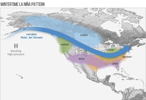
La Niña affects US weather through its impact on the Asia-North Pacific jet stream, which is retracted to the west during a La Niña winter and often shifted northward of its average position. Generally, La Niña winters in the southern tier of the US (including Texas) tend to be warmer and drier, while the northern tier states and Canada tend to be colder. The latest seasonal outlook for Texas calls for the weather to trend drier-than-normal beginning in November, with drier-than-normal weather continuing into early spring. Temperatures are predicted to average warmer-than-normal fall through winter.

Climate Prediction Center forecasters state there is an approximately 75 percent chance for La Niña conditions to persist through the Northern Hemisphere winter.
Bob


Social Media