Forecast for Central Texas

 50%50%50%
 20%0%
20%0%
Reports from LCRA’s Hydromet
Rainfall summaryTemperature summary
Humidity summary
Bob's Blog on Central Texas Weather
Periods of Rain and Scattered Thunderstorms Wednesday through Friday
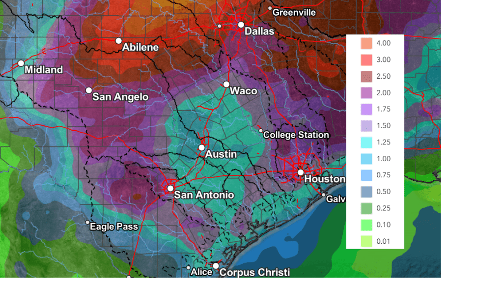
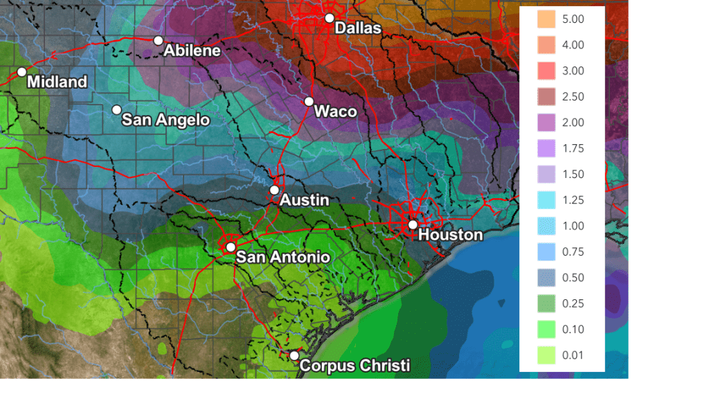
This weekend’s trough of low pressure and cold front brought some much needed rain to the region. Totals were highest across the northern Hill Country, where amounts of 2-3 inches were recorded to the north and northwest of Lake Brownwood. The western half of the Hill Country received between 1 and 1.5 inches, while the eastern half saw totals closer to a half inch. Amounts were much lower across Central Texas and the middle Texas coast, where most totals were under a quarter inch.
Some pockets of heavy rain developed Monday morning along the middle Texas coast in the vicinity of the stalled out cold front. LCRA’s gauge located near Sargent, in southeastern Matagorda County, recorded 4.21 inches, while LCRA’s gauge near the town of Matagorda, in southern Matagorda County, recorded 3.01 inches. (as of 2:30 pm)
We’re looking at an unsettled weather pattern this week as a series of low pressure troughs push east out of Mexico and track across Texas. This development is something we haven’t seen much of this spring, and should lead to periods of rain and thunderstorms across our region. Unfortunately, the highest totals of rain are expected to be across the northern and eastern parts of the state.
Monday’s weather will be sunny and warm for the majority of the region. However, there will be a 40-50 percent chance for scattered showers and thunderstorms for the coastal plains Monday afternoon and Monday evening, for the area to the south of U.S. Highway 59. Additional totals of 0.5 t0 1 inch will be possible. The cold front along the coast is predicted to lift back to the north Monday night, allowing warm and more humid air to spread back over the area.
- High temperatures Monday are forecast to generally be in the low and mid-80s, with some upper 80s possible across parts of Central Texas
- Lows Tuesday morning will range from the low 60s across the Hill Country, to the upper 60s near the coast
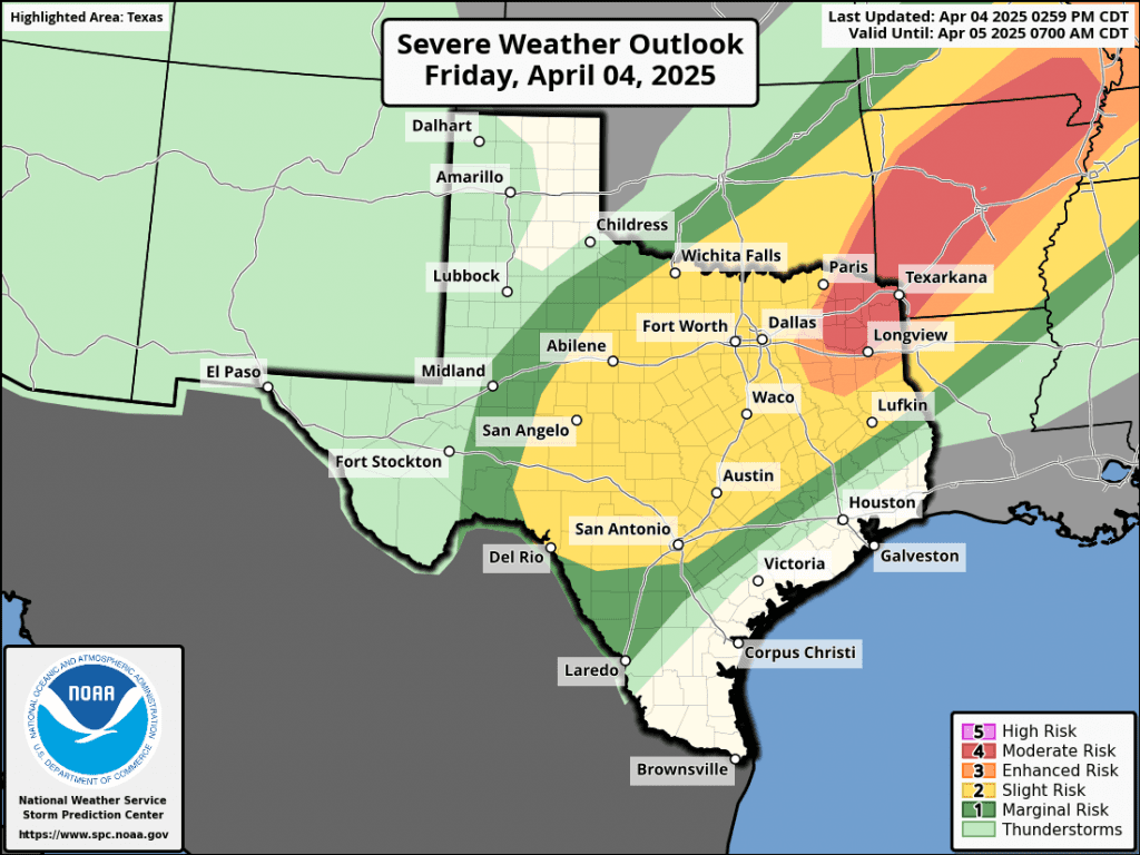
Widespread low clouds and even some patchy fog are forecast to develop Monday night, continuing through Tuesday morning. A partly cloudy sky is expected Tuesday afternoon. Due to increasing moisture and a slightly unstable air mass, a few scattered showers and isolated thunderstorms will be possible Tuesday afternoon and Tuesday evening. Forecasts point to the possible development of scattered thunderstorms late Tuesday afternoon into Tuesday evening across West Texas, along the dry line. Should thunderstorms develop, the atmospheric setup will allow some of these storms to become strong to severe. High resolution forecasts call for the developing storms to track to the east, possibly spreading over parts of the Hill Country and Central Texas Tuesday night into early Wednesday morning. Some of these storms may be strong to severe. Rain amounts from this wave of showers and thunderstorms is forecast to generally average between 0.25 and 0.5 inches.
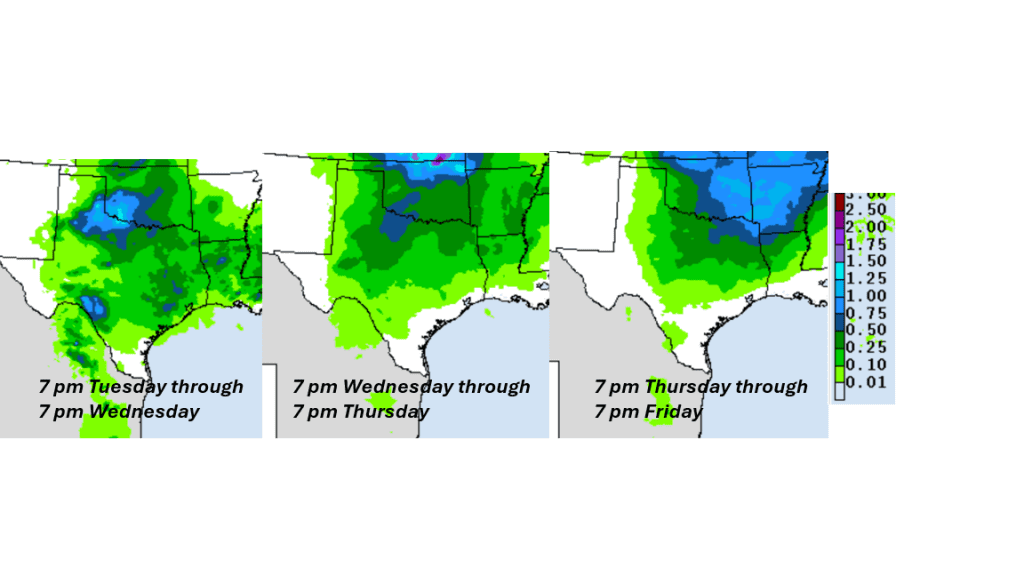
The highest chance for rain and scattered thunderstorms this week is expected to occur Wednesday and again on Thursday as two separate waves of low pressure track east across North Texas. On Wednesday, showers and scattered thunderstorms are forecast to increase in coverage in the afternoon and continue into Wednesday evening. The probability for rain will be near 50 percent. Scattered rain showers and thunderstorms are forecast to increase in coverage again Thursday afternoon and continue Thursday night into Friday as the second wave of low pressure moves over the area. The probability for rain will be near 50 percent. The chance for rain looks to decrease Friday afternoon into Friday night. Rain amounts Thursday through Friday are forecast to average around a quarter inch, with isolated heavier totals.
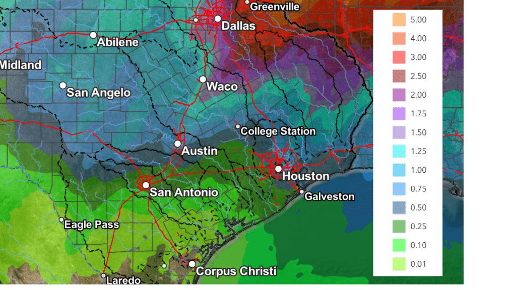
A breakdown of this week’s forecasted rain, from the National Weather Service:
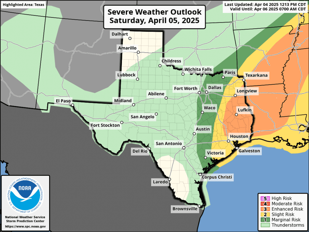
For the weekend, there will be a slight chance for a few showers on Saturday. Otherwise, the weekend is expected to be partly cloudy and warm, with highs around 88-90 degrees.
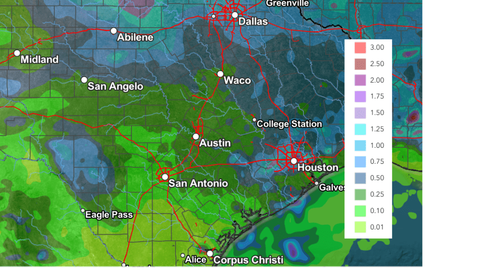
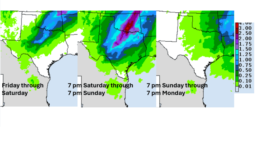
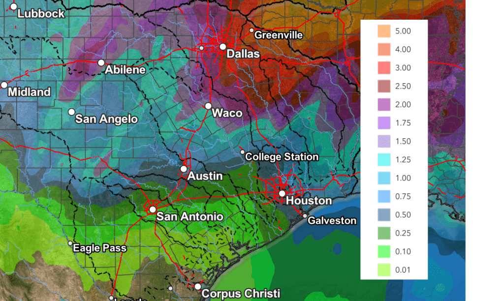
Cumulative rain totals through Saturday evening call for widespread totals between 0.25 and 0.5 inches, with isolated heavier totals.
NWS Rainfall Forecast Valid through 7 pm Saturday:
Looking ahead to next week, forecast solutions call for generally dry and warm weather next Monday and Tuesday, followed by a chance for scattered rain showers and thunderstorms next Wednesday through Friday as a weak cold front sinks to the south and stalls across Central Texas. High temperatures next week are forecast to hold in the mid and upper 80s.
Have a great week!
Bob
Previous Blog Entries
A Chance for Rain this Weekend, Continuing through Late Next Week
The persistent warm and dry weather pattern we’ve seen for most of April will finally begin to change this weekend and next week as an approaching trough of low pressure brings our region a chance for rain and scattered thunderstorms. This will be followed by additional chances for rain and storms next Tuesday through Friday. Parts of the Hill Country are forecast to receive between 1 and 2 inches of rain over the next seven days.
Friday’s weather is expected to be warm and breezy, with a partly to mostly cloudy sky. A strong pressure gradient across the state is expected to cause strong southerly winds with speeds of 10-20 mph and occasional gusts to 35 mph. It will be a warm day, with the temperature warming up to 88-90 degrees.
There will be a slight chance for the development of some scattered thunderstorms across the Hill Country region late Friday night as a small wave of low pressure pushes east out of West Texas. High resolution forecasts call for scattered thunderstorms to develop across The Concho Valley region late Friday evening, with the storms slowly pushing east-northeast across the Hill Country after midnight and toward daybreak on Saturday. There remains some uncertainty as to the amount of thunderstorm coverage across the Hill Country late Friday night as the storms will be moving into a fairly stable atmosphere. The probability for storms across the Hill Country late Friday night will be near 30 percent. Should the storms survive, they are predicted to remain sub-severe. For Central Texas and the middle Texas coast, breezy and warm conditions are forecast overnight, with lows near 70 degrees.
There will be a 30-40 percent chance for scattered rain showers and thunderstorms across the Hill Country and Central Texas regions Saturday morning through Saturday afternoon as another wave of low pressure begins to push east out of West Texas. At the same time, the atmosphere over the region is predicted to become quite moist and less stable. There will be a small chance an isolated thunderstorms or two across the Hill Country could become strong to severe Saturday afternoon. Severe weather threats will include large hail and damaging winds. Saturday’s weather will be mostly cloudy, breezy, and warm. Look for winds to gust to near 30 mph with high temperatures generally in the mid-80s.
The most favorable period for rain showers and thunderstorms over the weekend is predicted to occur Saturday night into Easter Sunday when a large trough of low pressure tracks northeast across the Texas Panhandle, pushing a Pacific cold front southeast into the Hill Country and Central Texas. Forecasts call for an area of showers and thunderstorms to develop across the Concho Valley and Big Country regions in advance of and along the cold front Saturday night.
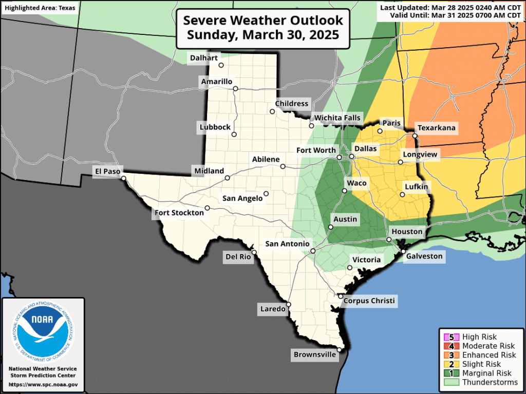
The area of rain and storms is predicted to spread into Hill Country by about midnight Saturday night, with the area of rain continuing to spread to the east and southeast. Atmospheric condition may support some of the thunderstorms to be strong to severe. The Storm Prediction Center has placed the area west of Interstate 35 under a Slight Risk, or a 2 out of 5 risk, for severe thunderstorms through 7 am Sunday. The primary severe weather threats will be large hail and damaging winds. The rain activity is predicted to taper off from west to east Sunday morning. Expect a partly cloudy sky Sunday afternoon.
The area of rain and thunderstorms is forecast to shift to the Interstate 35 corridor and Central Texas near, or just after sunrise Sunday morning. The area of thunderstorms is forecast to be weakening as it exits the Hill Country and spread into Central Texas. The threat for severe storms is expected to be fairly low. The rain and thunderstorm activity is forecast to taper off from northwest to southeast Sunday morning as the cold front moves to the southeast. Expect a partly cloudy sky Sunday afternoon.
For the middle Texas coast, showers and scattered thunderstorms are forecast to spread into the area Sunday morning and continue Sunday afternoon and Sunday evening as the cold front slows down and stalls near the coast. The probability for rain will be near 70 percent, decreasing to 50 percent Sunday night.
High temperatures Easter Sunday are forecast to be in the upper 70s to low 80s.
Rain amounts through Monday morning are forecast to average between 0.25 and 0.5 inches across the Hill Country, and close to close to a quarter inch across Central Texas and the middle Texas coast.
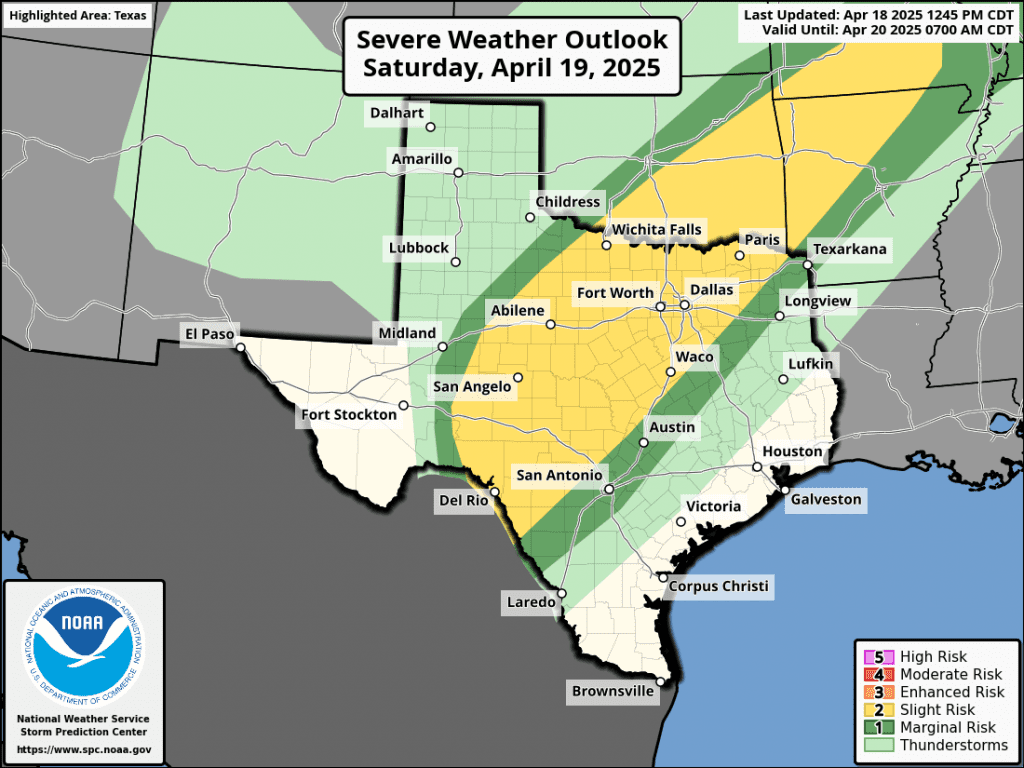
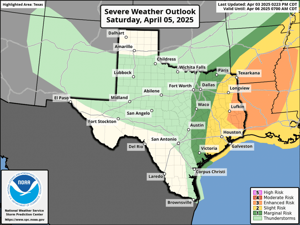
Severe Weather Outlook for Saturday and the NWS Rainfall Forecast Valid through 7 pm Monday
Monday’s weather is expected to be mostly sunny across the Hill Country and Central Texas region. Meanwhile, there will be a 40-50 percent chance for scattered rain showers for the middle Texas coast where the front remains stalled. Rain amounts are forecast to be around a quarter inch.
The outlook for next Tuesday through Friday calls for a 40-50 percent chance for rain showers and scattered thunderstorms across the entire region as a series of low pressure troughs move over Texas out of the southwestern U.S. and northern Mexico. Daily rain amounts of 0.25 to 0.5 inches are forecast. The latest data shows the thunderstorm activity remaining below severe threshold.
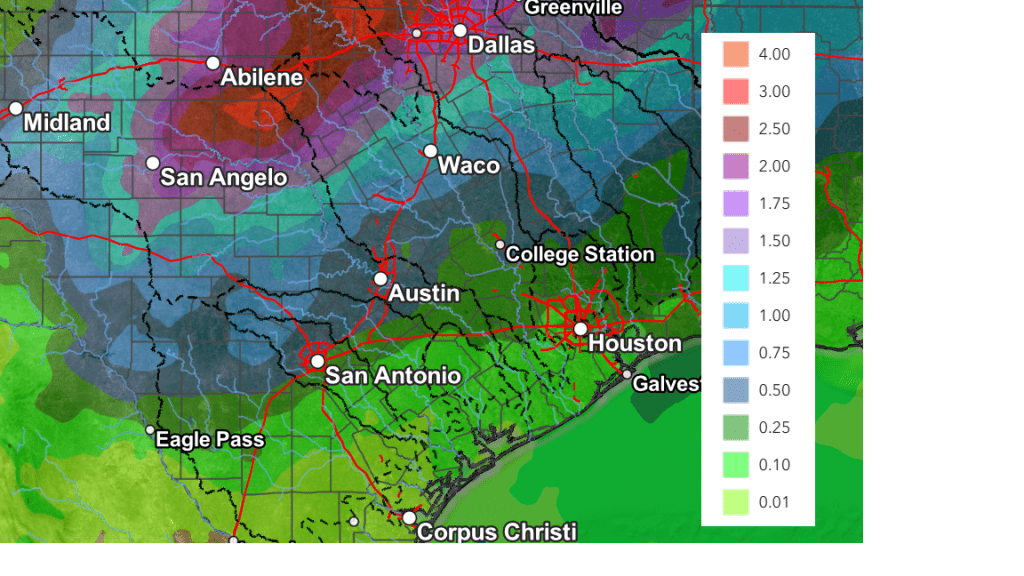
National Weather Service forecasts call for rain amounts over the next seven days to total between 1 and 1.5 inches across the Hill Country, and between 0.5 and 1.25 inches across Central Texas and the middle Texas coast.
NWS Rainfall Forecast Valid through 7 pm Next Friday:
High temperatures next week are forecast to be mostly in the low and mid-80s.
Looking out a little further, dry weather is forecast to return next weekend, but the long-range solutions are indicating another chance for rain returning to the forecast around the beginning of May.
Have a great weekend!
Bob
Warm and Dry this Week. A Chance for Rain Developing Over the Weekend
Dry and quiet weather conditions are forecast through late week as our region remains under the stable influence high pressure situated over the south central U.S. and northern Mexico. Some changes to the weather pattern are expected this weekend and next week as the ridge slides off to the east, allowing for a more unsettled weather pattern to take shape. A chance for rain will finally return to the forecast.
A trough of low pressure pushing east across the northern Plains states is helping to push a weak cold front south into Texas. As of early Monday afternoon, the front stretched from Sherman to Abilene, to near Fort Stockton. The front is predicted to slowly move south across the Hill Country and Central Texas regions after midnight Monday night, then pull up stationary along the middle and upper Texas coast Tuesday morning. Unfortunately, the atmosphere will be too dry for the development of any rain along the front. The front is expected to bring slightly cooler temperatures for Tuesday and Tuesday night before warmer air returns on Wednesday. Ahead of the front, more unseasonably warm readings are forecast.
- High temperatures Monday are predicted to be in the low and mid-90s across the Hill Country and Central Texas regions, and in the mid-80s across the coastal plains
- Lows Tuesday morning will generally be around 60-62 degrees
- High temperatures Tuesday will include the upper 70s across the Hill Country, the low 80s across Central Texas, and the low to mid-80s towards the coast
- Low temperatures Wednesday morning will range from the mid-50s across the Hill Country, to the low 60s near the coast
Mostly sunny, breezy, and warmer weather can be expected Wednesday through Friday as the cold front lifts back to the north. This will allow warm and more humid air to spread north from the Gulf. Expect southerly breezes each day of 10-15 mph, with occasional gusts to around 35 mph.
- High temperatures Wednesday will be in the low and mid-80s, warming to the mid and upper 80s for Thursday and Friday
- Lows Thursday and Friday mornings are forecast to be in the low and mid-60s
Changes to the stationary weather pattern will finally begin to take place this weekend when the ridge over Texas moves to the east. At the same time, a large trough of low pressure is predicted to move into the western and southwestern U.S. out of the Pacific. Forecasts call for the large trough to track east across the southern Plains and northeast to the Great Lakes this weekend and early next week. The low is expected to pull considerable Gulf moisture north into Texas beginning late Friday, continuing through the weekend. This will result in a mostly cloudy sky. While the main trough is forecast to pass north of Texas, small weaker troughs of low pressure are forecast to move across the state over the weekend, helping to cause a chance for scattered rain showers and thunderstorms. Additional chances for scattered rains look to extend into the early and middle parts of next week as well as more weak disturbances move over the region.
Forecasts call for a 30 to 40 percent chance for rain and thunderstorms Saturday and Saturday night, increasing to a 40 to 50 percent Sunday through early next week. The highest totals of rain are forecast to occur across the northern Hill Country and the northern counties of Central Texas, with the lowest totals to the south.
NWS Rainfall Forecast for Saturday, Sunday, and Monday:
NWS Cumulative Rainfall Valid through 7 pm Monday:
Scattered showers and thunderstorms through the first half of next week will have the potential to cause scattered daily totals in the range of 0.25 to 0.5 inches.
The outlook for late next week into the following weekend calls for generally dry weather and warm temperatures, with highs in the mid-80s.
Have a good week!
Bob
Continued Dry with Some Tastes of Summer-Like Temperatures
A dry and quiet weather pattern has taken shape across Texas, the southwestern U.S., and northern Mexico thanks to the development of a large ridge of high pressure in the middle and upper atmosphere. The ridge is forecast to slide directly over Texas this weekend and early next week, then shift back west for the second half of next week. Similar to a summertime ridge over our area, the current ridge will keep potential storm systems away from Texas, leading to rain-free weather and unusually warm temperatures for the next week to ten days.
As of late Thursday morning, a weak Pacific cold front was located across central Oklahoma, moving to the south. The front is predicted to reach north central Texas and the Concho valley regions Thursday evening, then push south across Central Texas and the middle Texas coast Thursday night. The atmosphere will be too dry for any clouds or rain with the front. However, the front is forecast to bring a 2-4 degree drop in the temperature Friday. Warmer, summer-like temperature are forecast to develop this weekend when the ridge moves overhead and southerly winds return to the area. The weekend will see breezy conditions, with southerly winds of 10-15 mph. Gusts to around 30 mph will be possible on Sunday.
- High temperatures Thursday are forecast to be near 88-90 degrees across the Hill Country and Central Texas regions, and in the mid-80s across the coastal plains
- High temperatures Friday will be in the low and mid-80s
- High temperatures Saturday are predicted to be in the mid and upper 80s
- Highs Sunday are forecast to be near 90-92 degrees across the region
- Low temperatures will generally be in the upper 50s to low 60s.
For next week, forecasts call for more summer-like heat on Monday. However, another weak cold front looks to slide south across the area sometime late Monday into early Tuesday, bringing slightly cooler air for Tuesday and Wednesday. Once again, the atmosphere will likely be too dry for any rain with the front. Summer-like heat is forecast to return next Thursday and Friday, with temperatures moderating down slightly for next weekend.
- High temperatures Monday are forecast to be near 90-92 degrees
- Highs Tuesday and Wednesday will generally be in the mid-80s
- High temperatures next Thursday and Friday are forecast to again be near 90-93 degrees
- Low temperatures next week will generally be in the upper 50s to low 60s
Long-range forecasts indicate a slight chance for rain may take shape across the area sometime next weekend or the early part of the following week when a Pacific trough of low pressure tracks to New Mexico and southern Colorado. Unfortunately, no widespread or heavy rain is forecast over the next 10-day period.
Adios La Niña
NOAA’s Climate Prediction Center announced Thursday La Niña has ended and the Pacific has returned to a state of ENSO-neutral, where neither La Niña nor El Niño are in place.
For what might follow La Nina, the Climate Prediction Center’s forecast team indicates a probability well above 50% for ENSO-neutral conditions to continue through summer and into October. Beyond early fall, the outlook becomes more uncertain. The forecast team’s prediction for November through January shows a 43% chance for ENSO-neutral conditions persisting, and a 38% chance for a return of La Niña. There’s no clear answer at this point. Unfortunately, the chances for El Niño to return this fall are not very strong, and are under 20%.
Hopefully, the development of ENSO-neutral conditions will lead to a more variable and changeable weather pattern across Texas as we move into May and June.
Bob
Dry and Stable Weather Expected throughout the Week
Monday started off unusually cool, with the temperature dipping into the 30s as far south as Interstate 10. According to LCRA’s Hydromet, lows were generally in the mid-30s across the Hill Country, in the upper 30s across Central Texas, and in the low to mid-40s across the middle Texas coast. It is interesting to note there were a fair number of Hill Country locations that did see the temperature fall to, or below freezing. The Hydromet’s lowest recorded temperature was 26 degrees near Fort McKavett, in eastern Schleicher County. Close to Austin, the temperature fell to 28 degrees along Cow Creek near Lago Vista, in northwestern Travis County. Austin’s official low temperature was 39 degrees at both Camp Mabry and Austin-Bergstrom International Airport. San Antonio recorded a low of 40 degrees.
A dry and very stable weather pattern is now in place across Texas as the system responsible for Saturday’s rainy/cold weather shifts to the East Coast. Forecasts call for a ridge of high pressure currently covering southern California and northwestern Mexico to spread east this week and into the upcoming weekend. This feature will keep our weather sunny and rain-free throughout the week. At the surface, light northeasterly winds are forecast to continue this afternoon and tonight. However, southerly breezes will return on Tuesday, causing warmer temperatures that will likely stick around for the remainder of the week. Southerly breezes are forecast to increase to 10-15 mph, with gusts to 25 mph on Wednesday.
A weak, dry cold front is predicted to push south through the area Thursday afternoon and Thursday night. The front will mainly cause the wind to shift out of the north with speeds of 10-20 mph and gusts to 30 mph Thursday afternoon and Thursday night. The front is not expected to bring any appreciable change to the temperature late week or this weekend.
- High temperatures Monday are forecast to be around 68-72 degrees
- High temperatures Tuesday are predicted to be in the upper 70s, warming to the lower 80s on Wednesday
- High temperatures Thursday and Friday are forecast to be in the mid-80s
- Weekend high temperatures are predicted to be in the upper 80s
- Low temperatures Tuesday morning look to be around 40 degrees across the Hill Country, and in the low 40s at most other locations
- Lows Wednesday morning are predicted to be in the low 50s
- Lows Thursday and Friday mornings are forecast to be in the mid and upper 50s
- Lows Saturday and Sunday mornings are predicted to be in the upper 50s to low 60s.
Looking out into next week, forecast solutions call for a trough of low pressure to move into the Four Corners region early next week, with the trough slowly lifting east-northeast into the southern Plains states next Wednesday and Thursday. Only a modest return of Gulf moisture is expected out ahead of the trough. Forecast solutions call for a slight chance for rain across the area the middle of next week as a Pacific cold front associated with the trough moves across Texas. Rain amounts, if any, are forecast to average less than a quarter inch.
Temperatures look to stay warm next week, with highs well into the 80s, and lows in the 60s.
Fire Weather Concerns Returning Wednesday and through the Weekend
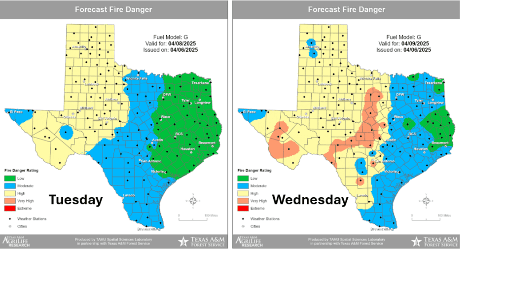
Elevated fire weather concerns are forecast to develop across the Edwards Plateau and much of the Hill Country Wednesday through Monday as relative humidity values fall to the teens and 20th percentile each of those days.
The Texas A&M Forest Service Fire Danger Forecast maps show the increase fire danger starting Wednesday:
Have a good week!
Bob
Strong to Severe Storms Possible Friday Night. Turning Much Colder Sunday and Early Next Week
Showers and scattered thunderstorms are forecast to develop across the Hill Country and Central Texas regions Friday afternoon, but the main round of strong to severe thunderstorms will come Friday night into Saturday morning when a trough of low pressure and Pacific cold front push to the east out of West Texas. The area of rain and storms is expected to spread across the middle Texas coast.
For Friday afternoon, expect a mostly cloudy sky across the region. There will be 30-40 percent chance for scattered rain showers and thunderstorms across the Hill Country and Central Texas regions as the atmosphere becomes a bit more unstable in advance of a large trough of low pressure pushing east from northern Mexico and southern Arizona. Most of the storm activity Friday afternoon is expected to remain below severe thresholds. High temperatures Friday will range from low and mid-70s across the northern Hill Country, to the low 80s across Central Texas, to the upper 80s towards the coast.
Moving into Friday evening, additional scattered rain showers and isolated thunderstorms are forecast across the Hill Country and Central Texas regions as the atmosphere becomes increasingly unstable. Some of these thunderstorms may be strong to severe.
The most favorable period for rain showers and thunderstorms is expected to take place after midnight Friday night when a Pacific cold front pushes east out of West Texas and the Edwards Plateau. High resolution forecasts call for a large area of showers and thunderstorms to develop along the cold front across Edwards Plateau around midnight, with the showers and storms spreading east across the Hill Country, the Interstate 35 corridor, and parts of Central Texas between midnight and 6 am. Some of these thunderstorms may be strong to severe. The primary severe weather threats will be large to significant hail of 2 inches in diameter or greater, and damaging wind gusts of 60 mph. In addition to the severe weather threats, pockets of heavy rain will also be possible. The Storm Prediction Center has placed the Hill Country and most of Central Texas under a Slight Risk, or a 2 out of 5 risk, for severe thunderstorms through 7 am Saturday. Behind the main area of rain and thunderstorms, lighter rains and a couple of isolated thunderstorms look to continue till about midday Saturday.
For the eastern counties of Central Texas and the middle Texas coast, the leading edge of the showers and thunderstorms is forecast to spread across the area beginning shortly after daybreak and continue Saturday morning through Saturday afternoon. There is a chance for some of these thunderstorms to also be strong to severe. Similar to areas to the west, the primary severe weather threats will be large hail and damaging winds. The Storm Prediction Center has placed easter Colorado, Wharton, and Matagorda Counties under a 2 out of 5 risk for severe thunderstorms on Saturday. A transition to mostly light showers and isolated thunderstorms is predicted for late Saturday afternoon and early Saturday evening.
The Storm Prediction Center’s Severe Weather Outlook for Friday and Saturday:
The rain is forecast to taper off from west to east across the Hill Country and Central Texas regions Saturday afternoon. Across the coastal plains, the rain should taper off by late Saturday evening.
Projected rain amounts from Friday afternoon through Saturday evening continue to call for totals of 1-1.5 inches across the Hill Country, around 1 inch across Central Texas, and between 0.25 and 0.5 inches for areas south of Interstate 10.
NWS Rainfall Forecast Valid through 7 pm Sunday:
A rather strong Canadian cold front is forecast to push south through the area Saturday evening and Saturday night, bringing breezy and much colder air! In fact, this looks to be an unusually cold air mass for early April and it looks to last into the middle of next week. Plan to drag the coats and jackets back out of the closet. Expect northwesterly winds at 15-20 mph, with gusts to near 30 mph to develop Saturday night and continue through Sunday afternoon. Wind speeds should decrease Sunday night into Monday morning. The sky is forecast to be partly to mostly cloudy Sunday, followed by a clear sky on Monday.
Sunday night into Monday morning is shaping up to be the coldest period of the next few days.
A light freeze looks possible over parts of the Hill Country Monday morning!
- Low temperatures Sunday morning are forecast to be in the low and mid-40s across the Hill Country and Central Texas regions, and into the upper 40s across the coastal plains
- Low temperatures Monday morning are predicted to be in the low and mid-30s across the Hill Country, into the upper 30s across Central Texas, and into the low and mid-40s across the coastal plains
- Lows Tuesday morning are forecast to be in the low 40s across the Hill Country and Central Texas regions and in the mid-40s towards the coast
- Lows Wednesday morning will generally be in the upper 40s to low 50s
High temperatures are forecast to be in the 50s to low 60s Sunday, warming to the 70s Monday and Tuesday. Highs will move back into the 80s next Wednesday through Friday.
A sunny and dry weather pattern will be in place all of next week, continuing into next weekend. The next chance for rain is not expected until just after the middle of the month.
Have a great Weekend!
Bob
Strong to Severe Storms Possible Friday. CSU Issues First Hurricane Outlook
For Thursday into Thursday evening, weather conditions are expected to be partly cloudy and quiet. Expect breezy southeasterly winds with occasional gusts to 25 mph.
Scattered thunderstorms are forecast to develop across parts of West Texas and the Concho Valley late this evening and toward midnight when a trough of low pressure pushes east out of West Texas. This area of thunderstorms is then forecast to spread over parts of the Hill Country and possibly as far east as the Austin/Interstate 35 corridor Thursday night and toward daybreak Friday. Some of these storms, should they develop, may be strong to marginally severe. The primary severe weather threat will be large hail. The probability for storms is forecast to be near 50 percent across the Hill Country, and only near 20 percent in the Austin area and the Interstate 35 corridor.
Attention will then turn to Friday afternoon and Friday night when a large trough of low pressure over Arizona begins moving to the east, helping to push a Pacific cold front east across Texas. High resolution forecasts indicate the atmosphere across the Hill Country and Central Texas regions ahead of the cold front will become fairly moist and moderately unstable. This is expected to lead to the development of scattered strong to severe thunderstorms. The primary severe weather threats will be large hail and damaging winds.
The Storm Prediction Center has placed all of the Hill Country plus the Austin/Interstate 35 corridor under a Slight Risk, or a 2 out of 5 risk, for severe thunderstorms Friday into Friday night. The eastern half of Central Texas has been placed under a 1 out 5 risk for severe thunderstorms. The probability for rain and storms Friday is predicted to be near 50-60 percent.
The Pacific cold front is forecast to slowly push to the east Friday night and is expected to reach the I-35 corridor around daybreak Saturday. The front will continue to move east to the coast Saturday morning into Saturday afternoon. Widespread rain showers and scattered thunderstorms are forecast to spread across the Hill Country and Central Texas regions along and behind the cold front Friday night into Saturday morning. Rain and scattered thunderstorms are predicted to spread across the middle Texas coast Saturday morning through Saturday afternoon.
The rain is forecast to taper off from west to east midday Saturday through late Saturday afternoon.
Rain amounts through Saturday are expected to be heaviest across the Hill Country, where totals of 1-1.5 inches are forecast. Totals of 0.5 to 1 inch are forecast across Central Texas. For the middle Texas coast, totals are forecast to be between 0.25 and 0.5 inches.
NWS Rainfall Forecast Valid through 7 pm Sunday:
Dry weather and much cooler weather will follow the cold front Saturday night into the first half of next week. I’ll have more details on this in Friday’s update.
CSU Forecasters Predict An Active 2025 Atlantic Hurricane Season
Another unusually active Atlantic hurricane season is likely in 2025. In their first seasonal forecast of 2025 Thursday, the Colorado State University hurricane forecasting team, led by Phil Klotzbach, called for 17 named storms, 9 hurricanes, and 4 major hurricanes. This is higher than the 1991-2020 long-term averages of 14.4 named storms, 7.2 hurricanes, and 3.2 major hurricanes. Last year’s season produced 18 named storms, 11 hurricanes, and 5 major hurricanes.
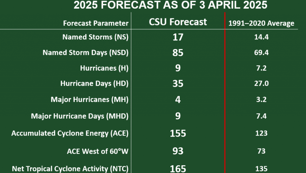
The CSU forecast used a statistical model that has been honed from more than 40 years of past Atlantic hurricane statistics, plus dynamical model output from four different model groups.
La Niña conditions in the Eastern Pacific have been weak in recent months, and most models are either forecasting neutral or weak La Niña conditions for the peak of the Atlantic hurricane season. In addition, sea surface temperatures are much warmer than average in the western and central Atlantic and eastern subtropical Atlantic. Meanwhile, waters in the eastern tropical Atlantic are near to slightly below average. in the eastern tropical Atlantic. According the CSU team, the enhanced warmth in the eastern subtropical Atlantic and in the Caribbean correlates well with what is typically seen in April before active Atlantic hurricane seasons.
Bob
A Chance for Showers Late Week and through the Weekend
There will be a couple of opportunities for thunderstorms across the Hill Country and Central Texas regions this week, but the best chance for a more widespread coverage or rain and storms looks to occur Friday into Saturday morning when a large trough of low pressure and cold front move across the state. Expect warm temperatures all of this week, followed by noticeably cooler readings this weekend and for most of next week. Lows early next week are forecast to fall to the 40s at most locations. Some upper 30s will be possible across the Hill Country.
A weak cold front pushed south through the area Sunday night into Monday morning, bringing a influx of drier and slightly cooler air that will likely extend into Tuesday morning. The front is forecast to move back north as a warm front Tuesday afternoon, bringing a return or warmer and more humid air. Expect light winds Monday, followed by breezy conditions, with gusts to near 30 mph on Tuesday.
- Monday’s high temperature will generally be in the mid and upper 70s across the Hill Country and Central Texas, with mid and upper 80s towards the coast
- Lows Tuesday morning are forecast to be in the low and mid-50s, with low and mid-60s across the coastal plains
- High temperatures Tuesday are predicted to be in the mid-80s
- Lows Wednesday morning will be in the mid and upper 60s, with low 70s expected towards the coast
Tuesday night into Wednesday morning, there will be a chance for scattered rain showers and thunderstorms across the Hill Country and the northern half of Central Texas (including the Austin metro area) when a weak cold front sags southeast out of northwest Texas. The probability for rain will range from 40 percent across the northern Hill Country, to just 20 percent in the Austin area. The atmospheric setup near and south of the front appears somewhat favorable for some of the storms to become strong to severe. The Storm Prediction Center has placed the area along and west of a line stretching from just east of Waco, to Austin, to just north of San Antonio under a Marginal Risk, or a1 out of 5 risk, for severe thunderstorms Tuesday evening through 7 am Wednesday. Large hail and damaging winds will be the primary severe weather threats. For areas that happen to see rain, amounts are predicted to average less than a half inch.
A second and somewhat better chance for scattered showers and thunderstorms for the Hill Country and Central Texas regions is forecast to occur Wednesday night into Thursday morning when passing disturbance to our north will help spark the development of scattered showers and thunderstorms along and north of Tuesday’s stalled cold front. Once again, some of the thunderstorms may be strong to severe. The Storm Prediction Center has placed most of the Hill Country and the northern counties of Central Texas under a 1 out of 5 risk for severe thunderstorms through 7 am Thursday. For locations that happen to see rain, totals once again are forecast to average less than a half inch.
High temperatures Wednesday and Thursday are forecast to be warm, with highs in the upper 80s to 90 degrees. Lows Thursday and Friday mornings are predicted to be near 70-72 degrees.
A more widespread coverage of rain showers and thunderstorms is forecast to occur beginning Thursday night, when a large trough of low pressure starts to move to the east out of the western and southwestern U.S., dragging a Pacific cold front into the state. In advance of the front, warm and humid air will spread north from the Gulf. Scattered showers and thunderstorms are forecast to develop Thursday night, then increase in coverage Friday through Friday night. Additional periods of rain are forecast to continue into Saturday morning as the cold front slowly spreads east through the region. The majority of the rain is forecast to taper off from west to east midday Saturday through late Saturday afternoon as drier and a somewhat more stable air spreads in behind the cold front. However, a slight chance for a showers looks to continue Saturday night through midday Sunday as an area of weak atmospheric lift spreads in behind the cold front.
Rain amounts Thursday through Sunday are forecast to range from about 1-1.25 inches across the northern Hill Country, to near 0.5 to 1 inch around the Austin area, to between 0.25 and 0.5 inches across the coastal plains.
NWS Rainfall Forecast for Valid through 7 pm next Monday:
Cooler air will spread south across the area Saturday afternoon and Saturday night behind the cold front and remain in place through the middle of next week. Sunny and dry weather is forecast next Monday through Friday as weak ridge of high pressure sets up over the south central U.S.
- Lows Sunday morning are forecast to be in the mid-40s across the Hill Country, the upper 40s across Central Texas, with upper 50s near the coast
- High temperatures Sunday are predicted to be in the low 60s across the Hill Country and Central Texas regions, and in the upper 60s across the coastal plains
- Lows next Monday morning will include the low 40s across the Hill Country, the mid-40s across Central Texas, and upper 40s across the coastal plains
High temperatures Monday through Wednesday are forecast to be in the 70s. Lows Tuesday and Wednesday mornings will be in the 40s. Warmer temperatures will return next Thursday and Friday with highs returning to the 80s, with lows in the 50s.
Bob
Dry Weather Returning this Weekend, Continuing through the Middle of Next Week
Very moist air spreading north from the Gulf produced very beneficial rains across much of the area late Wednesday through Thursday night. While parts of the area saw totals of close to 2 inches, the highest totals from this rain event occurred across Deep South Texas, to the south of Laredo and Corpus Christi, where there were widespread 5 to 8 inch totals. Intense rains produced storm totals of 15-20 inches along the urban corridor between McAllen and Brownsville, resulting in catastrophic flash flooding.
NWS Estimate of Rain Falling Between 7 am Wednesday and 7 am Friday:
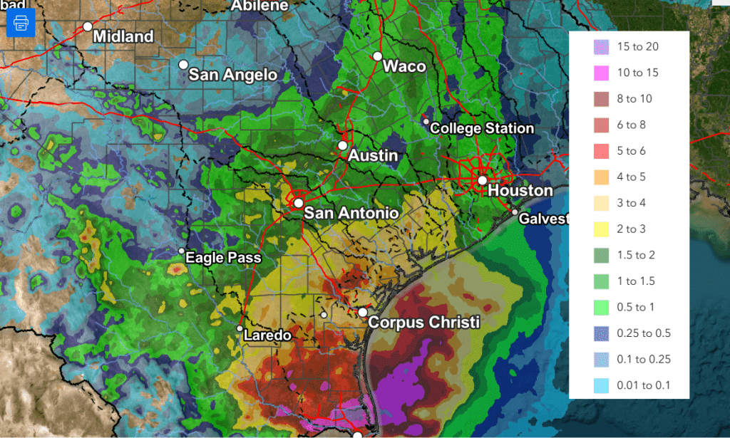
According to LCRA’s Hydromet, the lowest totals of rain over the past couple of days occurred across the northern and western Hill Country, generally west of a line stretching from Junction to San Saba. Totals through 9 am Friday across this area averaged less than a quarter inch. Across the remainder of the Hill Country and Central Texas, most totals averaged between 0.5 and 1 inch, with a few isolated heavier totals. Across the middle Texas coast, amounts generally averaged between 1 and 2.5 inches. The Bay City area in Matagorda County, appears to have received the most rain through 9 am Friday, with a total of 3.22 inches.
While additional rain is forecast Friday afternoon, the threat for heavy, flooding rain has diminished. Because of this, the National Weather Service has canceled the Flood Watch which had been posted for the middle Texas coast and parts of Central Texas. Widespread light to moderate rain and isolated thunderstorms are forecast from the eastern Hill Country, southeast to the Texas coast Friday afternoon as a trough of low pressure slowly moves east out of Central Texas.
- The probability for rain will range from 40 percent across the eastern Hill Country, to 70 percent across Central Texas, to 90 percent across the coastal region
- The chance for rain looks to diminish from west to east late Friday afternoon into Friday evening
- Additional rain amounts through Friday evening are forecast to average around a quarter inch or less across Central Texas, and between 0.5 and 1 inch across the coastal plains
A cloudy sky is forecast Friday night into Saturday morning. Clouds will decrease and the sky will become mostly sunny Saturday afternoon. A similar pattern of morning clouds and afternoon sunshine is forecast for Sunday. With the sunshine, the temperature is expected to be a bit warmer over the weekend.
A trough of low pressure pushing northeast out of the southern Rockies on Sunday will help to push a cold front south through the Hill Country, Central Texas, and coastal region Sunday afternoon into Sunday night. While large-scale lift associated with trough is expected to remain north of our area, atmospheric conditions ahead of and along the cold front may support the development of a few widely scattered thunderstorms—mainly across the northeastern Hill Country and the northern half of Central Texas. The probability for rain will be 20 percent. Some of these storms could possibly become strong to severe. The Strom Prediction Center has placed these two areas under a Marginal Risk, or 1 out of 5 risk, for severe thunderstorms Sunday afternoon into Sunday night. The primary severe weather risks will likely be large hail and damaging winds.
- High temperatures Friday will generally be in the mid 70s
- Highs Saturday are forecast to be in the low and mid-80s
- High temperatures Sunday will generally be in the mid-80s, with upper 80s across the Hill Country
- Low temperatures Saturday and Sunday mornings are forecast to be in the low and mid-60s
- Lows Monday morning will range from the mid-50s across the Hill Country, to the mid and upper 60s near the coast
The first half of next week is shaping up to be mostly sunny and warm. Sunday’s cold front is predicted to move back to the north late Monday, allowing for a return of southerly winds and warmer temperatures.
- High temperatures are forecast to be in the upper 70s Monday, warming to the low and mid-80s Tuesday
- High temperatures Wednesday are predicted to be near 90-92 degrees, with upper 80s near the coast
- Lows will generally be in the upper 50s to mid-60s
The outlook for Thursday through next weekend, calls for more sunny and warm weather. However, there will be a slight chance for scattered afternoon and evening thunderstorms each day across the Hill Country and Central Texas regions as a series of weak troughs track move across the southern Plains. Significant or heavy rain is not expected. Forecasts point to a somewhat better chance for rain for the entire region around Monday, April 7th and 8th. No significant change in the temperature is forecast over the next ten days.
Have a good weekend!
Bob
Wet Pattern Will Continue through Friday Evening. Dry and Warmer this Weekend
A wet weather pattern continues across Central and South Texas. As of early Thursday afternoon, the highest totals of rain so far have occurred across Deep South Texas and the Coastal Bend regions, with much lower totals further recorded further to the north. The western half of the Hill Country had yet to receive any rain.
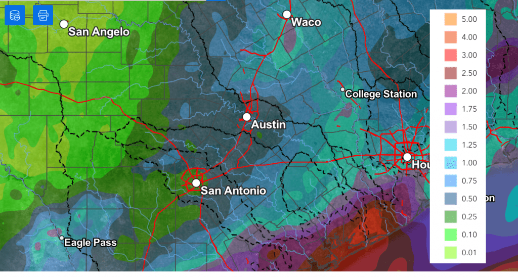
A widespread coverage of rain showers and scattered thunderstorms is forecast across the region Thursday evening and Thursday night, continuing through Friday afternoon as a large trough of low pressure pushes east out of northern Mexico. With a very moist air mass in place, showers and scattered thunderstorm activity is expected to increase as the upper trough pushes east into Texas. Waves of showers and thunderstorms are forecast to spread over the area Thursday night, continuing through Friday. Some of the rain may at times be locally heavy. The probability for rain will be near 50 percent across the Hill Country and near 90-100 percent across Central Texas and the middle Texas coast.
Thursday’s forecast model solutions continue to struggle with the location of the highest rain totals over the next 24 hours. It’s worth noting there’s been a general trend over the last few model runs for the highest totals of rain to continue to be across the Coastal Bend region and the middle Texas coast, with lower totals further inland. As a result, updated rainfall forecasts now call for lower rain totals for the Hill Country and Central Texas regions, compared to earlier forecasts.
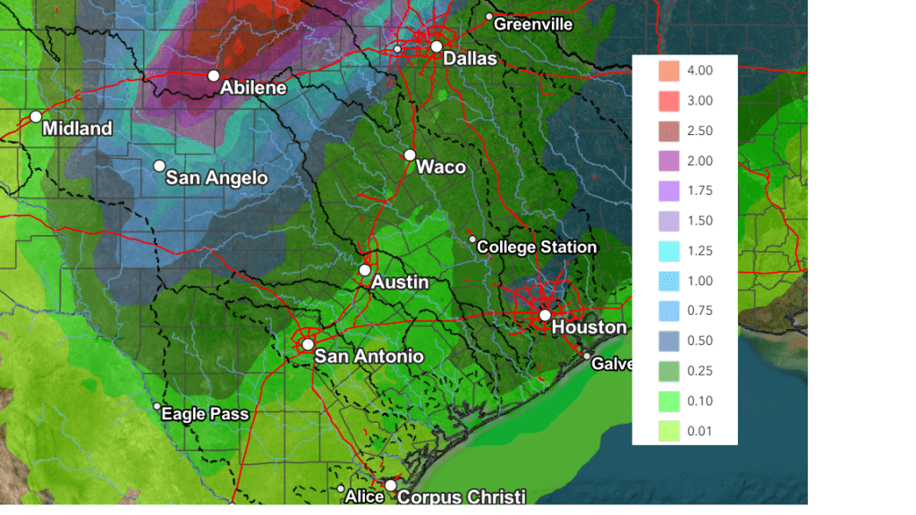
Updated National Weather Service rainfall forecasts through late Friday afternoon call for totals of 0.25 to 0.5 inches across the western and central Hill Country, with totals of 0.5 to 1.25 inches across Central Texas. For the middle Texas coast, totals of 1-3 inches are forecast, with isolated amounts to near 5 inches possible.
NWS Rainfall Forecast Valid through 7 pm Friday:
A Flood Watch remains posted for Colorado, Wharton, and Matagorda Counties through Friday evening.
A very low-end threat for strong to severe thunderstorms will continue for most of the area through Friday afternoon. It will be possible an isolated thunderstorms or two could produce large hail and damaging winds. But a widespread severe threat is certainly not anticipated.
A chance for additional light rain showers will continue into Friday evening. However, the chance for rain is predicted to end from west to east late Friday evening and toward midnight as the upper trough finally exits to the northeast.
This weekend’s weather is forecast to be mostly sunny and warm, with high temperatures in the mid-80s. The next chance for rain is expected to occur late week when a new trough of low pressure tracks east from the southwestern U.S.
Bob
Social Media