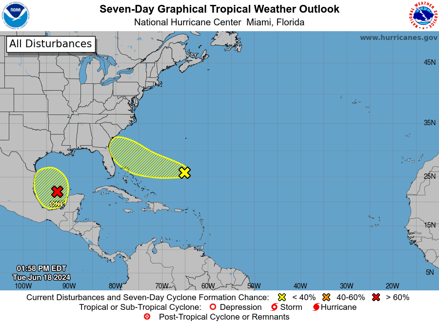
As of early Tuesday afternoon, Potential Tropical Cyclone One was located over the southwestern Gulf of Mexico, about 405 miles southeast of Brownsville, Texas. While the disturbance’s overall envelope has become slightly better defined, there’s still no evidence that a well-defined center of circulation has developed. The system’s broad nature will likely continue to inhibit significant strengthening despite otherwise conducive environmental conditions. The global forecast model fields suggest the circulation will tighten up and develop a well-defined center on Wednesday while the system approaches the northeastern coast of Mexico. Maximum sustained winds are currently near 40 mph, with some higher gusts. Some increase in strength is likely during the next 36 hours. The disturbance is forecast to move inland over Mexico on Wednesday, having no direct impact on Central Texas weather.
Meanwhile, a moist flow off the Gulf of Mexico is causing the development of scattered light rain this afternoon from the middle Texas coast into Central Texas. The showers should continue into Tuesday evening. Today’s analysis shows a large area of deep tropical moisture lurking just offshore over the northwestern Gulf of Mexico. This slug of moisture is forecast to spread inland along the middle Texas coast after midnight Tuesday night, and continue spreading west into parts of Central and South Texas and parts of the Hill Country Wednesday into Thursday. The tropical moisture is forecast to spread west into Rio Grande Plains and Mexico late Thursday into Friday.
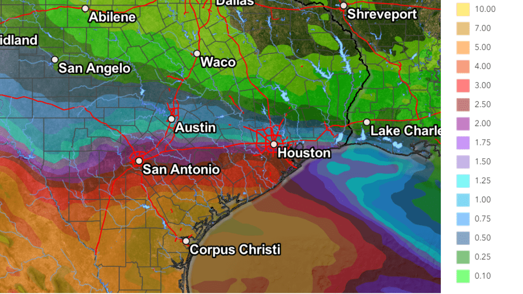
Tuesday’s forecast data indicates the bulk of the deep tropical moisture will most likely stay to the south of Interstate 10 Wednesday into Thursday due a stronger ridge of high pressure located across the southern U.S. As a result, lower amounts of tropical moisture and rainfall are now predicted across Central Texas and the Hill Country, compared to Monday’s prediction.
High resolution forecasts call for a large area of moderate to heavy rain to spread inland along the middle Texas coast around midnight Tuesday. Periods of locally heavy rain will be possible here Tuesday night through Wednesday evening. The area of rain is forecast to spread into the southern counties of Central Texas around daybreak Wednesday, reaching the Interstate 35 corridor around midday, and the Hill Country region Wednesday afternoon. As pointed out above, the heaviest rains are expected to occur near and south of Interstate 10. Widespread moderate rain is forecast to occur across Central Texas and the Hill Country Wednesday into Wednesday night. The large area of moderate to heavy rain is forecast to shift west into Edwards Plateau region late Wednesday night. Note some periods of locally heavy rain will also be possible across Central Texas and the Hill Country. In addition, wind gusts to 30 mph can be expected with some of the passing showers.
The National Weather Service has posted a Flood Watch for the middle Texas coast through late Wednesday night. A Flood Watch has also been posted for the southern counties of Central Texas through Thursday afternoon.
The National Weather Service’s Tuesday afternoon rainfall forecast through Thursday now calls for general totals of 3 to 6 inches across the middle Texas coast. Across Central Texas totals are forecast to range from 1-2 inches around Austin, to near 3 inches around La Grange. Across the Hill Country, totals are forecast to range from a half inch near Brownwood, to around 3 inches in Kerrville.
NWS Rainfall Forecast for the Period 7 pm Tuesday through 7 pm Friday:
There will be a 50-60 percent chance for showers and thunderstorms across the region Thursday, followed by a 40-50 percent chance for more scattered rain showers and thunderstorms on Friday. A slight chance for rain showers will continue through the weekend.
Looking out longer term, the National Hurricane Center is indicating another broad area of low pressure could develop over the southwestern Gulf of Mexico this weekend. Environmental conditions are expected to be conducive for gradual development of this system early next week while it moves slowly northward or northwestward. It’s too early to get a handle on whether this potential system might bring another round of rain to our area, or not.
Bob
Social Media