The Chance for Rain will Continue into Wednesday. Dry Weather Late Week into the Weekend
SEPT. 3, 2024
It was a wet weekend for much of West Texas, the Hill Country, and coastal locations. A nearly stationary area of low pressure over West Texas brought repeated rounds of rain showers and thunderstorms to the area. Doppler radar estimates since Saturday morning show widespread totals of 4 to 6 inches falling over the area from south of San Angelo to northeast of Abilene. There have also been a few pockets of 8 to 10 inch totals. Across the Colorado River basin, gauge totals since Saturday have generally been between 1 and 2 inches across the western Hill Country. Meanwhile, the northern Hill Country, from Brady to north of Brownwood, has received between 2 and 7 inches. Along the middle Texas coast, totals of 1-2 inches were recorded across Matagorda County. Central Texas totals since Saturday have generally been less than a tenth of an inch.
NWS Estimate of Rain Falling Between 7 am Saturday and 7 am Tuesday:
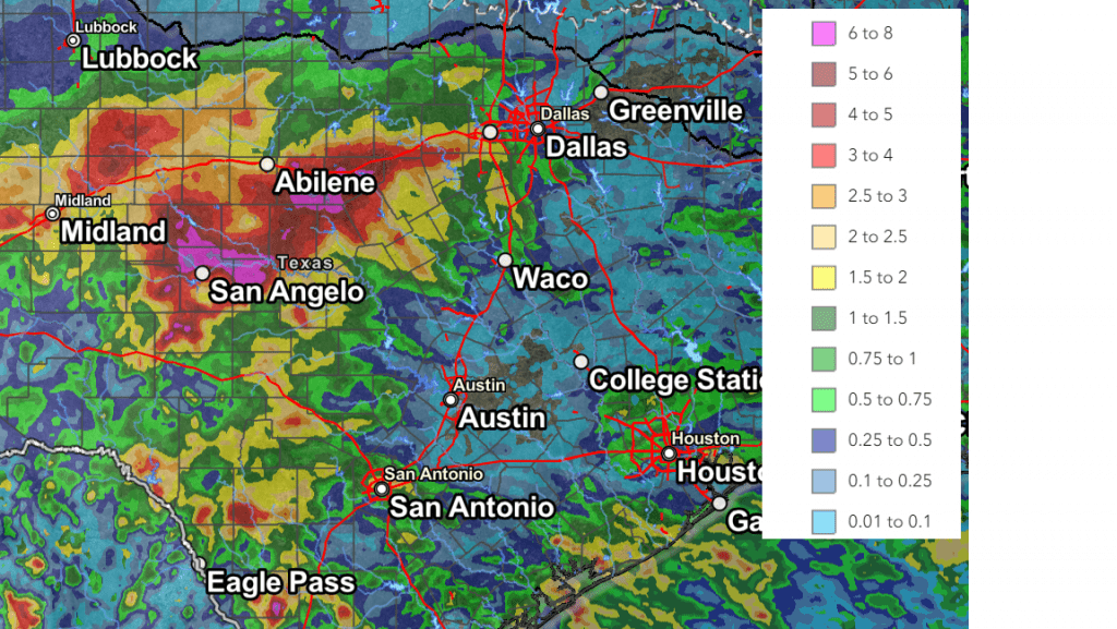
Data courtesy NWS West Gulf River Forecast Center
Tuesday’s weather maps continued to show an unsettled pattern across the state. An area of low pressure persists across Northwest Texas, while a weak cold front stretched from Ozona, to Temple, to near Lufkin. Forecasts call for the low pressure system over West Texas to move off to the northeast on Wednesday. The cold front is predicted to slowly push south towards the middle Texas coast late Wednesday.
For Tuesday afternoon Wednesday afternoon, the most favorable area for rain is again forecast to be across West Texas, including the western and northern Hill Country where waves of rain showers and scattered thunderstorms will continue. The probability for rain is forecast to be near 50 percent. Additional totals of 1-3 inches will be possible. Isolated totals to near 5 inches can be expected. The National Weather Service has posted a Flood Watch through late Tuesday night for much of West Texas, including the western and northern Hill Country.
For the eastern Hill Country and Central Texas regions, including Colorado County, periods of light to moderate rain are forecast Tuesday afternoon through Wednesday afternoon. The probability for rain will be near 50 percent. Totals through Wednesday afternoon are forecast to average between 0.25 and 0.5 inches, with isolated totals to near 1 inch possible.
For Wharton and Matagorda Counties, periods of rain showers and thunderstorms are forecast Tuesday afternoon through Wednesday afternoon. The probability for rain will be near 60 percent. Totals through Wednesday afternoon are forecast to average between 0.5 and 1 inch, with isolated totals to near 2 inches possible.
The chance for rain is forecast to decrease significantly across the Hill Country and Central Texas regions beginning Wednesday night as the low pressure system moves off to the northeast and drier air spreads in behind the weak cold front. There will be a 20 percent chance for a few lingering isolated rain showers across the area Thursday afternoon. Expect a partly cloudy to mostly sunny sky. Meanwhile across the coastal plains, a chance for rain showers and thunderstorms looks to continue Wednesday night through Thursday afternoon, with additional totals to near 1 inch possible.
Sunny and dry weather is forecast across the entire region Friday as the cold front pushes further to the south, bringing drier and more stable air to the entire region. Expect high temperatures near 88-90 degrees.
Forecasts call for a second, dry cold front to push south across the area late Friday night into Saturday morning that will bring with it considerably drier air. This drier air is expected to be in place through the weekend and early next week. Weather conditions are forecast to be sunny and dry. Weekend high temperatures are predicted to be near 88-90 degrees. Pleasant evenings and nights are forecast thanks to the drier air. Lows Sunday through Tuesday mornings will include the upper 50s to low 60s across the Hill Country, the low 60s across Central Texas, and the mid-60s across the coastal plains.
The outlook for next week calls for dry conditions throughout the week as Texas comes under the influence of a weak ridge of high pressure situated across northern Mexico and the Desert Southwest. Daily high temperatures are forecast to generally be in the low 90s, with lows in the mid-60s to near 70 degrees.
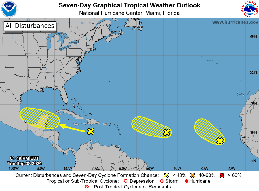
Tropical Weather Outlook
The area of low pressure which had been parked off the upper Texas coast since Friday has weakened and the system no longer poses a threat for tropical development. The system is forecast to move off to the northeast over the next couple of days.
The National Hurricane Center is monitoring three tropical waves that show a low potential for development over the next few days.
The first wave was located over Hispaniola and portions of the central Caribbean Sea. As this system moves westward, some development is possible when it reaches the western Caribbean Sea and the southwestern Gulf of Mexico late this week or over the weekend. NHC forecasters are giving this system a 30 percent chance for tropical development over the next seven days. The cold front pushing south across Texas this week should keep this system on a westward/northwestward path toward southern Mexico.
The second wave was located about midway between the west coast of Africa and the Lesser Antilles. Some slow development is possible during the next couple of days while the system moves west-northwestward. By the end of the week, however, environmental conditions are expected to become unfavorable for additional development. NHC forecasters are giving this system only a 10 percent chance for development over the next seven days.
The third tropical wave was located over the far eastern Atlantic. Some slow development of this system will be possible during the next few days as it moves west-northwestward or northwestward over the eastern tropical Atlantic Ocean. Environmental conditions are expected to become less conducive by the end of the week. NHC forecasters are giving this system a 30 percent chance for tropical development over the next seven days.
Summer 2024 Climate
Meteorological summer came to an end Saturday, and while August featured a spell of some very hot weather, the summer overall was less hot and a bit wetter, compared to summer 2023.
In Austin, Camp Mabry’s average temperature was 86.7 degrees, which was 1.6 degrees above normal. Summer 2024 tied with summer 2008 for the 7th warmest summer on record.
For comparison, summer 2023’s average temperature was 89.4 degrees, which was 4.3 degrees above normal. Summer 2023 was the second hottest summer on record.
Between June 1 and August 31 of 2024, Camp Mabry recorded 30 days with temperatures at or above 100 degrees. For comparison, summer 2024 featured 69 days of triple digit temperatures.
Austin recorded 6.33 inches of rain over the summer, which was 2.05 inches below normal.
Bob
Social Media