The summer doldrums have arrived. We’ve reached the point of summer where there will be little day to day change in the weather. The heat is on and long-range forecast solutions are showing no real break from the very hot temperatures through at least the first couple of weeks of July. Meanwhile, the tropics have become active, with three areas of disturbed weather posing a threat for tropical development.
Friday’s analysis showed a broad ridge of high pressure in the middle and upper atmosphere, or heat dome, stretching from northwestern Mexico to the mid-Atlantic states. Forecasts call for the heat dome to remain across Texas this weekend and all of next week, causing continued dry and very hot weather across Central and South Texas. The center, or most intense part of the heat dome, is forecast to be over the southern Plains this weekend, then slowly shift east to the southeastern U.S. for the middle and latter parts of next week. Even with the center of the heat dome shifting more to the east, little change in the temperature is predicted locally over the next few days.
- High temperatures Friday through Sunday are forecast to be near 98-101 degrees across the Hill Country and Central Texas regions, and in the mid to upper 90s across the coastal plains.
Relative humidity levels are forecast to remain elevated this weekend and next week. The combination of the very hot temperatures and fairly high relative humidity levels is expected to produce peak heat index readings between 105 and 110 degrees for areas along and east of Interstate 35 today through late next week.
The National Weather Service has posted a Heat Advisory for the Austin/Interstate 35 corridor and areas southeast to the coast through 7 pm Friday. Additional heat Advisories will likely be issued for this same general area over the next few days. Under a heat advisory, officials urge everyone to drink plenty of fluids, stay in an air-conditioned room as much as possible, stay out of the sun, and check up on relatives and neighbors.
While no rain is forecast for the Hill Country and Central Texas regions through late next week, a few isolated, spotty rain showers will be possible for areas located to the south of Interstate 10 as the sea breeze front pushes north from the coast. Isolated totals to near a quarter inch will be possible from the spotty rain over the next few days.
Expect a southerly breeze with speeds of 10-15 mph Friday afternoon and Saturday. Wind speeds are forecast to decrease to 5-10 mph Sunday and early next week.
Looking out a little further, little change in the weather is predicted for the week of July 8th. Forecasts call for the center of the heat dome to return west to southern Colorado and northern New Mexico, causing continued very hot and dry weather across our region. Daily high temperatures are predicted to be close to 100 degrees.
Tropical Weather Outlook
National Hurricane Center forecasters are monitoring three areas of disturbed weather that have potential for tropical development over the next few days.

- In the western Caribbean Sea, forecasters are monitoring a broad area of low pressure that is associated with a strong tropical wave. This system continues to produce widespread clouds along with showers thunderstorms. Development of this system is not expected today while it moves west-northwestward toward the Yucatan Peninsula. The disturbance is expected to emerge over the Bay of Campeche late Saturday or early Sunday, at which point, some development will be possible. NHC forecasters are giving this feature a 30 percent chance for tropical development over the seven days. The large heat dome located over the southern U.S. is forecast to keep this system on a path that will take it well to the south of Texas.
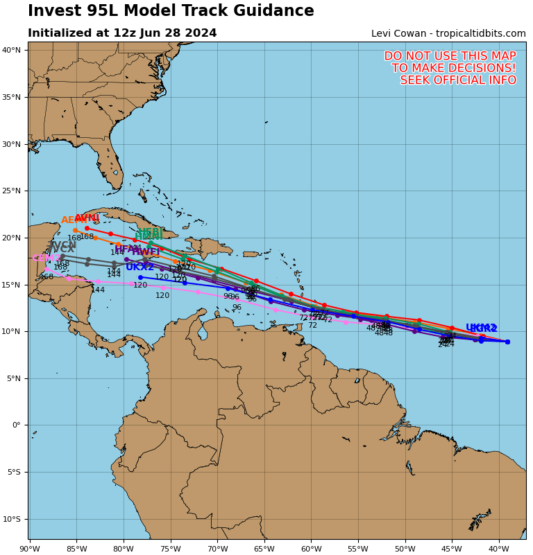
- In the central tropical Atlantic, a low pressure system is located about 1400 miles east-southeast of the Windward Islands. Showers and thunderstorms with the system are increasing in organization and the system overall is gradually becoming better defined. According to the Hurricane Center, if these trends continue, a tropical depression will likely form sometime Friday evening. This system is expected to move westward at 15 to 20 mph and approach the Lesser Antilles by the end of the weekend. NHC forecasters are giving this system a 100 percent chance for tropical development over the next couple of days.
Friday’s various computer forecast solutions show good agreement on a path to the northwest over the next 4 days, with some spread in the solutions developing around day 5.
- Out across the eastern tropical Atlantic, a fairly strong tropical wave is centered several hundred miles south-southwest of the Cabo Verde Islands. The system is producing a fairly large area of disorganized showers and thunderstorms. NHC forecasters indicate some slow development of this system will be possible next week as the system moves to the west across the central and western tropical Atlantic. As of now, NHC forecasters are giving this system a 30 percent chance for tropical development over the next seven days.
I hope everyone has a good weekend and stays cool. If you’re planning to take part in outdoor activities, remember to take the necessary precautions to avoid heat-related illnesses. Drink plenty of water, wear light-colored clothing, take frequent breaks and LOOK BEFORE YOU LOCK! Also, for pets…if the ground is too hot for the palm of your hand, it is too hot for their paws!
Bob
Social Media