For the past couple of days, the clouds and rain associated with tropical storm Alberto created a nice break in the summer pattern across Central and South Texas. Unfortunately, this break is about to come to an end. As of Friday morning, the remnants of Tropical Storm Alberto continued to push west across central Mexico. Well to the north and east of the remnant circulation center, deep tropical moisture and scattered clouds continue to spread inland across Central and South Texas. As temperatures warm Friday afternoon, scattered rain showers and isolated thunderstorms are forecast to develop. The most favorable area for showers is expected to be over the area generally located to the south of Interstate 10. Here, the chance for rain for rain will be around 40 percent. Totals of 0.25 to 0.5 inch will be possible. Across Central Texas and the southern half of the Hill Country, the chance for scattered rains will be around 20 percent, with totals averaging less than a quarter inch. The shower activity is forecast to diminish Friday evening with the loss of heating. Friday’s high temperature is predicted to be in the low 90s.
After spending the past few days over the northeastern U.S., the subtropical ridge, or heat dome, is forecast to shift back southwest, spreading over the southern Plains states this weekend, reaching Mexico and the Desert Southwest early next week. The heat dome is predicted to remain over this same general area through late next week. Stable, sinking air along the periphery of the heat dome looks to spread across Texas this weekend causing the chance for rain to diminish and temperatures to warm. Tropical moisture associated with the next Gulf tropical disturbance (see tropical section below) could bring a few scattered rain showers to the coastal plains region Sunday and Monday, but the rest of the region should stay rain-free.
- High temperatures Saturday are forecast to be in the low to mid-90s Saturday
- High temperatures Sunday are forecast to be in the mid-90s
A sunny, hot and humid weather pattern is predicted for next week as the center of the heat dome settles in just west of our region.
- High temperatures Monday and Tuesday are predicted to generally be in the mid-90s
- High temperatures Wednesday through Friday are predicted to generally be in the upper 90s, with middle 90s towards the coast
Although the weather looks to stay dry, a steady influx of moisture off the Gulf of Mexico will maintain rather high relative humidity levels throughout the week. This will lead to peak heat index values between 105 and 110 degrees for much of the area throughout the week and into next weekend.
Looking out further into next weekend and the week of July 1st, the forecast solutions call for little change in the weather pattern. Sunny and hot weather looks to continue, with daily high temperatures around 98/99 degrees. We will be moving shortly into what is typically the driest month of summer.
Tropical Weather Outlook
National Hurricane Center forecasters forecast a broad area of low pressure to develop over the Bay of Campeche Friday evening. Environmental conditions appear conducive for gradual development of this system as it moves slowly west-northwestward or northwestward. A tropical depression could form over the southwestern Gulf of Mexico this weekend. NHC forecasters are giving this system a 60 percent chance for tropical development over the next seven days.
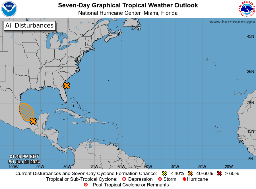
Clouds and moisture associated with this disturbance are forecast to spread into Mexico and Seep South Texas. The heat dome spread across Texas this weekend is predicted to keep most of the clouds and rain to the south of our area.
Full Strawberry Moon
June’s full moon will occur Friday evening at 8:08 pm CDT. Don’t miss it, it will be quite big and bright!
The strawberry’s moon’s name can be traced back to some Native Americans who used to call it by that name. It’s still common across North America today. Many species of berries ripen in early summer, including some strawberries.
Bob
Social Media