We are quickly moving into an active weather pattern that is expected to bring rounds of rain showers and thunderstorms to much of the Hill Country, Central Texas, and coastal regions for the next several days. Each of the periods of rain and thunderstorms will offer some potential for severe weather along with locally heavy rain. Forecasts are indicating this active pattern will last well into the month of May as more waves of low pressure approach from the west.
Friday
The first round of rain and thunderstorms developed early Friday morning across the Concho Valley ahead of a weak trough of low pressure that was pushing east out of West Texas. This area of thunderstorms tracked northeast across the northern Hill Country between Mason, Burnet, and Lampasas ands south to the Austin area Friday morning. There were radar indications the storms may have produced some large hail and strong winds between Burnet, Lampasas, and Temple. The storms are forecast to continue across this general area through mid-afternoon, then push northeast into East and Northeast Texas late Friday afternoon.
For Friday afternoon and Friday night, expect a mostly cloudy sky and breezy conditions. A fairly strong stable layer in lower atmosphere should limit the development of scattered shower and thunderstorm development. Forecasters will be closely watching for possible thunderstorm development mid to late afternoon along the Dry Line across the Big Country and northern Hill Country regions. The probability for thunderstorm development will only be 20 percent. However, any storms which develop will likely become severe. Expect southerly winds at 10-20 mph, with occasional gusts to 35 mph. Friday’s high temperature will be in the low 80s.
Saturday through Sunday
A moist and fairly unstable atmosphere is predicted to be in place across the region Saturday. However, a stable layer in the atmosphere is expected to limit thunderstorm development at most locations. Should a break in this stable layer develop, strong to severe thunderstorms will likely develop. The probability for rain and storms will only be near 20 percent. Morning clouds will give way to partly cloudy and windy conditions in the afternoon. Expect southerly winds at 15-25 mph, with gusts up to 40/45 mph. Saturday’s temperature is forecast to reach the low and mid-80s.
Confidence is quite high a large area of rain and thunderstorms will spread across the region Saturday night into Sunday morning as a strong wave of low pressure pushes east out of West Texas and New Mexico. Forecasts call for an area of thunderstorms to develop across western Texas Saturday evening, with the activity eventually merging into a broad line of showers and strong to severe thunderstorms around or after midnight. The rain and storms are predicted to spread east across the Hill Country after midnight Saturday night, moving into the Austin/Interstate 35 corridor around sunrise Sunday morning. The area of rain and storms should spread east across Central Texas and the middle Texas coast Sunday morning into Sunday afternoon. Some of storms may be severe. The Storm Prediction Center has placed the Hill Country under a Slight Risk, or 2 out of 5 risk, for severe thunderstorms through daybreak Sunday. The primary severe weather threats will be large hail and damaging winds.
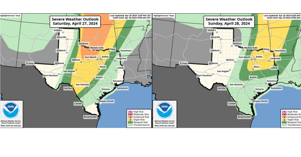
The rain is expected to taper off across the Hill Country and I-35 corridor by Sunday afternoon, and across the rest of the region by Sunday evening. Lingering instability will cause a slight chance for a few spotty showers behind the main line. Rain amounts through Sunday evening are forecast to average around 1-1.5 inches across much of the area. Lower totals are forecast for areas south of Interstate 10.
Monday through Late Next Week
Periods of rain showers and scattered thunderstorms are forecast through late next week as additional small waves of low pressure move across Texas out of Mexico and the Desert Southwest. Some of these storms may be strong to severe.
Monday through Wednesday, the probability for rain looks to be around 30-40 percent. Rain amounts each day are predicted to average around a quarter inch. Forecasts point to an increased chance for rain and thunderstorms Thursday into Friday as a weak cold front pushes south into the area. As of now, widespread rain amounts of 1-1.5 inches are forecast. High temperatures next week are forecast to remain mostly in the low and mid-80s.
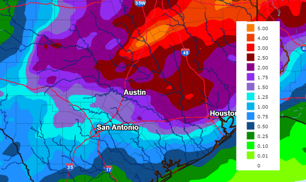
The National Weather Service’s total rainfall forecast for the next seven days indicates much of the area could see between 1 and 3 inches, with even higher totals possible across the northern Hill Country.
NWS Total Rain Forecast for Period through 7 pm Friday, May 3rd:
Looking out beyond late next week, forecasts show a chance for rain remaining in the forecast for the week of May 6th.
Bob
Social Media