Forecast for Central Texas

 30%
30% 50%
50% 20%20%0%
Reports from LCRA’s Hydromet
Rainfall summaryTemperature summary
Humidity summary
Bob's Blog on Central Texas Weather
Scattered Rain Showers and Thunderstorms Forecast through the Weekend
After several days of hot, rain-free weather, a chance for rain has returned to the forecast for Friday, the weekend, and early next week. The highest probability for rain and thunderstorms looks to occur Saturday, with lower chances following Sunday and Monday. Despite the chance for rain this weekend, hot temperatures look to continue, although not as hot as was observed Thursday.
Friday’s weather maps showed much of Texas was situated within a break between two ridges or high pressure, or heat domes. The first ridge was centered over Far West Texas, northern Mexico, and the Desert Southwest, while the second ridge covered most of the Gulf of Mexico and the southeastern U.S. Forecasts call for this break between the two ridges to shift further west into Texas late Friday and through the weekend. This “break zone” will allow tropical moisture to spread inland to Central Texas and the Hill Country and will be the source for the development of scattered afternoon showers and thunderstorms.
Meanwhile, forecasters are also monitoring the progress of a rare summer cold front that currently stretches east-west across North Texas. As of late Friday morning, the front stretched from San Angelo, to Waco, to Shreveport. The front is forecast to sink a little further to south Friday afternoon, then pull up stationary over the Hill Country and Central Texas on Saturday. The combination of the stalled front, a weaker ridge, and increased tropical moisture will cause a chance for scattered rain showers and thunderstorms across the region Friday afternoon through Monday afternoon.
- Friday afternoon into Friday evening, the probability for scattered rain and thunderstorms is forecast to be near 30 percent across the northern half of the Hill Country and Central Texas (including the Austin metro), and the middle Texas coast
- Saturday afternoon into Saturday evening, the probability for scattered rain and thunderstorms will be near 40-50 percent across the entire region
- For Sunday and Monday, the probability for scattered rain and thunderstorms looks to diminish across most of the Hill Country, while a 20-30 percent chance for rain and thunderstorms will continue for Central Texas and the middle Texas coast
Developing scattered showers and thunderstorms Friday through Monday are expected to move slow-movers and will have the potential to produce locally heavy downpours at a few locations. In general, daily rain amounts are forecast to average between a quarter and a half inch, with isolated totals of 1-2 inches.
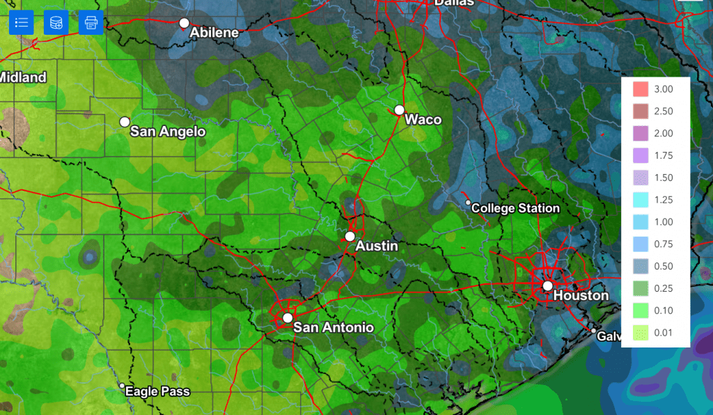
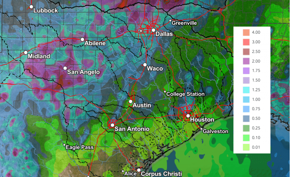
The National Weather Service’s rainfall forecast through Monday evening only shows cumulative totals of 0.25 to 0.5 inches. However, I do think believe totals will be a bit higher than what is shown.
NWS Rainfall Forecast Valid through 7 pm Monday:
- High temperatures Friday are forecast to be near 98-100 degrees at most locations
- High temperatures Saturday through Monday are predicted to be in the upper 90s
Mostly sunny, hot, and rain-free weather is predicted next Tuesday through Friday and next weekend. Forecasts call for the western ridge of high pressure located over northern Mexico and the Desert Southwest to expand east to cover all of Texas. Fortunately for us, the center of the ridge is predicted to remain over New Mexico and not directly over Texas. This should keep the hottest temperatures more out to the west.
- High temperatures Tuesday through next Sunday are forecast to be in the upper 90s to 100 degrees across the Hill Country and Central Texas regions, and in the mid to upper 90s across the coastal region
Looking out into the week of August 11th, little change is forecast. High temperatures are forecast to remain mostly in the upper 90s to 100 degrees.
Tropical Weather Outlook
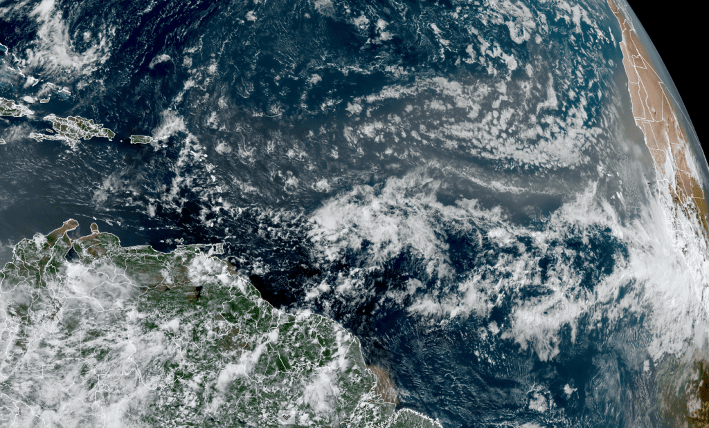
Weather conditions are currently quiet across the tropical Atlantic and are expected to remain that way over the next week.
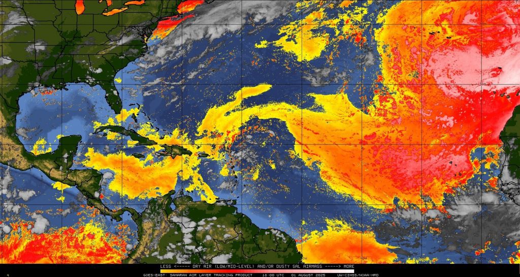
Friday’s satellite images showed a large area of Saharan dust (shown in the yellow and red colors) stretching from the Caribbean Sea to the west coast of Africa. A tropical wave can be seen just east of the Lesser Antilles, but it is surrounded by dry air and Saharan dust, creating unfavorable conditions for tropical development.
July Climate
The month of July ended with the temperature averaging between 1 and 2 degrees below normal across Central Texas and the middle Texas coast, and between 2 and 4 degrees below normal across the Hill Country.
Of course, unusually heavy and flooding rains were the big story for the month. Totals generally averaged between 6 and 12 inches above normal across most of the Hill Country. According to the Texas State Climatologist’s Office, for the Edwards Plateau climate division, the current July rain estimate for the area averages somewhere between 7.4″ and 7.7 inches. The previous wettest July on record occurred in 1976, with an area average of 7.12 inches. Among all months of the year for the Edwards Plateau, July’s estimate of 7.4 to 7.7 inches should place it somewhere between the 6th and 14th wettest month ever recorded. The final numbers from NCEI will be released on August 8th.
It’s interesting to note July rainfall averaged between 1 and 2 inches below normal across the middle and upper Texas coast.
Have a great weekend!
Bob
Forecasters Beginning to Monitor the Gulf
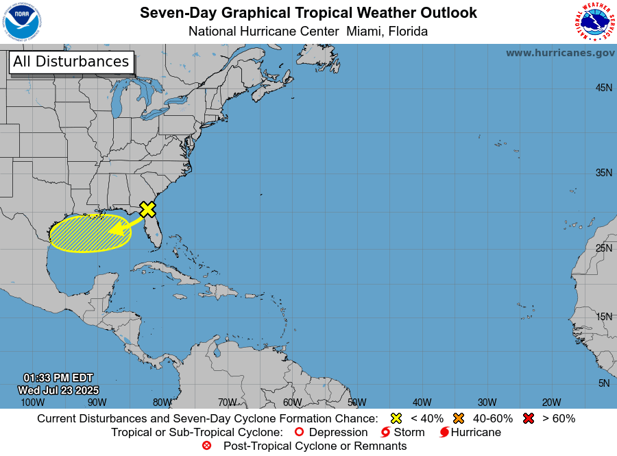
National Hurricane Center forecasters are currently monitoring a disorganized area of low pressure located just off the coast of the southeastern U.S. In a pattern somewhat similar to what happened a week ago, this system is producing scattered showers and thunderstorms across Florida, southern Georgia, and southern Alabama. This feature is predicted to cross over Florida and enter the eastern Gulf late Wednesday. Thursday into Friday, this system is forecast to move west-southwestward into the north-central Gulf, where atmospheric conditions are predicted to be somewhat favorable for some slow tropical development. The National Hurricane Center currently is giving this system just a 10 percent chance for tropical development over the next 48 hours. While most of the computer forecasts are not all that bullish for tropical cyclone development, additional weather balloon and forecast data coming in this morning will give NHC forecasters a better idea on the possibility for development.
Regardless of tropical development, the system is expected to bring a surge of deep tropical moisture into Southeast Texas and the middle Texas coast Friday through Sunday. Forecasts call for a 50 percent chance for rain and thunderstorms across the coastal Plains region all three days. In addition, some of this moisture is also predicted to spread into Central Texas and the eastern Hill Country regions Saturday and Sunday. Here, the probability for rain will be near 40 percent Saturday and 20 percent on Sunday.
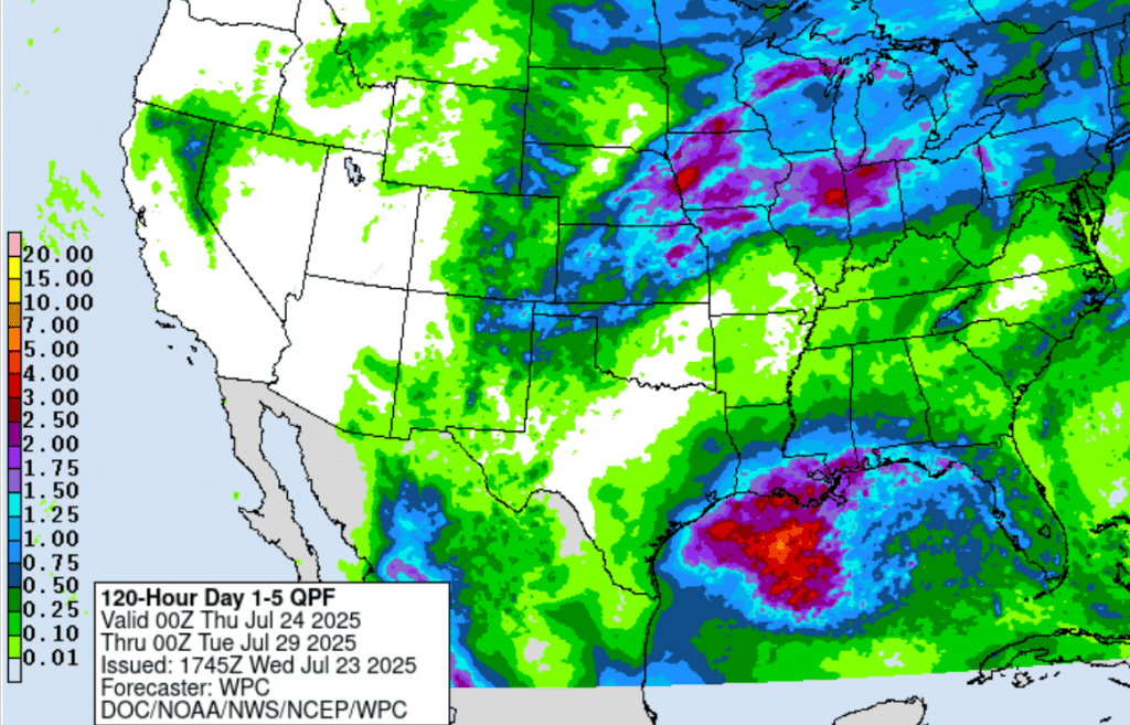
Rainfall from this system and its tropical moisture is forecast to be heaviest across the coastal region, while lower totals are expected further inland. The National Weather Service’s 5-day rainfall forecast through 7 am Monday calls for widespread totals to near a half inch across the coastal plains, and totals near a quarter inch or less across Central Texas and the Hill Country. Keep in mind, any surge of tropical moisture brings with it the risk of heavy rainfall.
I urge everyone to keep an eye on weather developments over the next few days for any changes.
Bob
This page was prepared on Wednesday, 07/23. For the latest weather information and forecasts, please consult the National Weather Service at weather.gov/ewx weather.gov/hgx and weather.gov/sjt
Sunny and Hot Weather Settling in for the Remainder of July
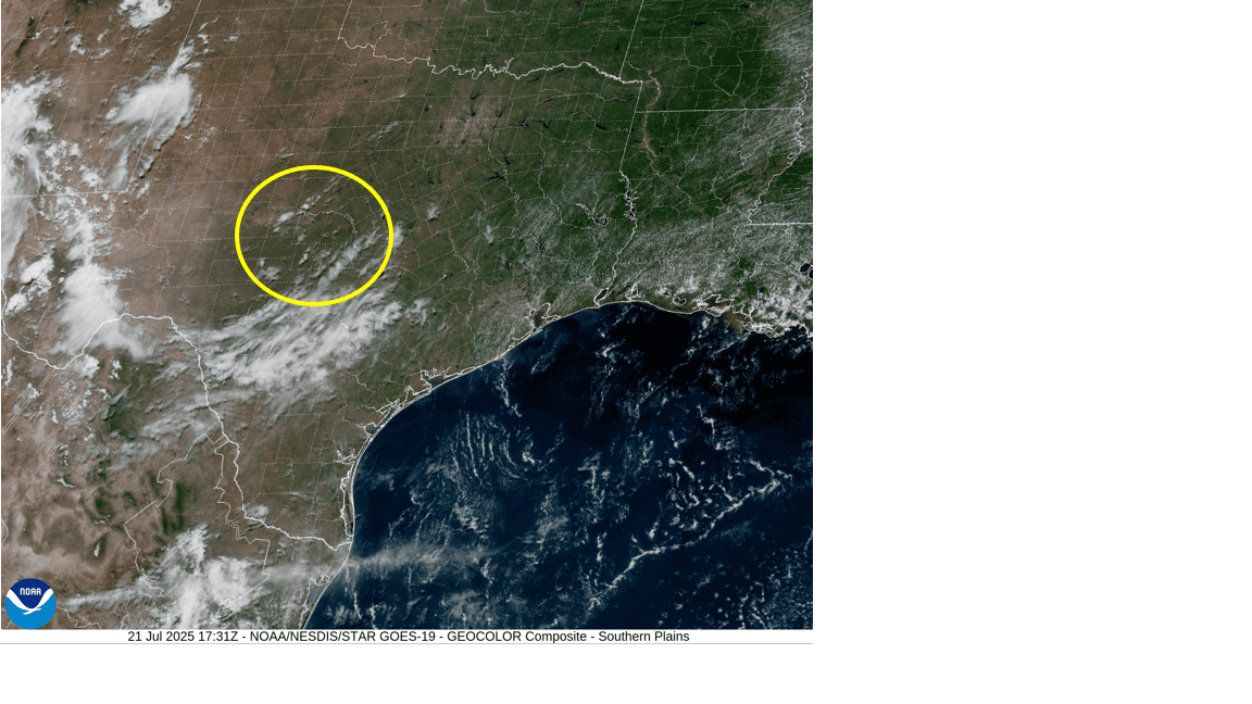
Quiet weather is in place as we start off the new week. For the past couple of days, much of the area has seen considerable middle and high-level clouds thanks to a weak area of low pressure which pushed inland along the upper Texas coast on Friday. As of midday Monday, the remnant low was centered over the northern Hill Country, moving slowly to the west. Satellite images show the low was still causing an area of clouds across the region. However, fewer clouds can be expected Monday afternoon, compared to past couple of days.
- High temperatures Monday are predicted to generally be in the mid-90s.
Mostly sunny, hot, and rain-free weather is for forecast Tuesday, continuing through the end of the week and the weekend as a large ridge of high pressure slowly sets up over the southern Plains states. Despite the ridge setting up to our north, no significant change in high temperatures is expected. Highs are predicted to remain mostly in the mid-90s. But do note a few spots across Central Texas could see highs in the upper 90s Thursday and Friday.
Several computer-forecast solutions indicate a low-pressure system is expected to break off a weak frontal zone located off the southeast US coast over the next couple of days. Like what occurred last week, this system is predicted to track south and then westward into and across the northern Gulf the second half of this week. As of now, the probability for tropical development with this low will be quite low. The low is expected to push another area of clouds and moisture inland along the upper Texas coast beginning Friday, continuing through the weekend. For areas located south of Interstate 10, there will be a 40 percent chance for scattered rain showers and thunderstorms Friday through Saturday, with rain amounts in the range of 0.5 to 0.75 inches. As of now, it doesn’t appear the chance for rain will extend into Central Texas or the Hill Country.
Cloud cover from this feature is expected to moderate temperatures slightly, keeping high temperatures mostly in the mid-90s through the weekend .
The outlook for next week shows continued sunny and hot weather n as the ridge of high pressure becomes a bit stronger. For Central Texas and the Hill Country, high temperatures the first half of the week are predicted to be in the upper 90s, then warm close to 100 degrees for the second half. Across the coastal plains, high temperatures are forecast to be in the mid to upper 90s throughout the week.
Tropical Weather Outlook
For the past couple of days, National Hurricane Center forecasters have been following the progress of a strong tropical wave located over the central tropical Atlantic. Monday’s analysis, including satellite-derived wind data, indicates the wave and its associated area of low pressure has become less organized. Although the wave is still producing disorganized showers and thunderstorms, environmental conditions are not expected to be conducive for development the next few days as the wave moves westward at around 15 mph.
NHC forecasters are giving this system just a ten percent chance for tropical development over the next seven days.
NOAA/Colorado State University/RAMMB 07/21/2025 1:40 pm CDT
Elsewhere, conditions remain quiet.
Have a great week!
Bob
This forecast was prepared Monday afternoon 7/21. For up to date weather forecasts and information 24×7, please consult the National Weather Service http://weather.gov/ewx weather.gov/hgx and http://weather.gov/sjt
Temperatures Trending Hotter Next Week. Little to No Rain on the Horizon
The tropical disturbance which tracked across the northern Gulf earlier this week pushed inland over southern Louisiana on Thursday. As of Friday morning, the ill-defined remnant tropical low had made its way into Southeast Texas.
NOAA/Colorado State University/RAMMB 07/18/2025 1:40 pm CDT
Forecasts call for the low to weaken and diminish late Friday into Saturday as it moves northwest into a drier and more stable atmosphere. Clouds and an area of tropical moisture associated with this feature are forecast to spread across the middle Texas coast and into the eastern half of Central Texas (including the Austin metro) Friday afternoon into Friday night. With a dry atmosphere in place across the area, the chance for rain will at or less than 20 percent. For areas that happen to see a spotty shower, totals should average less than a tenth of an inch. No rain is forecast across the Hill Country.
- The high temperature Friday is predicted to be in the low and mid-90s
Forecasts call for what’s left of the system to dissipate on Saturday. However, some of the leftover moisture could bring a spotty light shower or two to parts of Central Texas. Most areas will stay mostly sunny and dry.
- The high temperature Saturday and Sunday is again predicted to be in the low and mid-90s.
For Sunday and all next week, sunny, dry, and hot weather can be expected region wide. Forecast solutions call for a large ridge of high pressure currently centered over Florida, to spread to the west-northwest. The center of the ridge is predicted to set up over the southern Plains next weekend, then shift to the southern Rockies and the Four Corners region early next week. The presence of the ridge is expected keep weather conditions sunny, rain-free, and hot through the end of the month. Temperatures are predicted to trend hotter next week as soils begin to dry out and the center of the ridge gets closer to Texas.
- High temperatures next week are forecast to be in the mid-90s across the Hill Country and coastal regions, and in the upper 90s across Central Texas
- High temperatures next weekend are forecast to be in the mid and upper 90s at most locations
The outlook for the week of July 28th calls for continued sunny and hot weather. High temperatures are forecast to be close to 100 degrees across the Hill Country and Central Texas regions. No rain is predicted.
Tropical Weather Outlook
Weather conditions are currently quiet across the tropical Atlantic and tropical cyclone development is not expected over the next seven days.
I hope everyone has a safe and fun weekend! Stay cool!
Bob
Please Note: This outlook was prepared Friday afternoon, 7/18. For up to date weather forecasts 24×7, please visit the National Weather Service at weather.gov/ewx and http://weather.gov/hgx
Sunday Weather Update
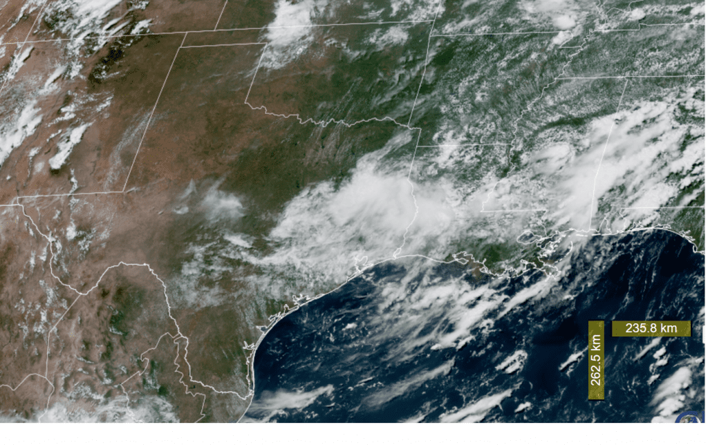
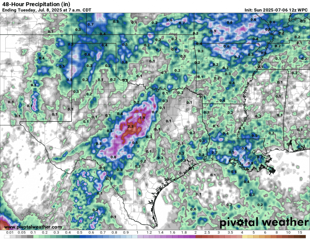
A large area of rain and thunderstorms took shape across the Concho Valley and northern Hill Country late Saturday night. The complex of rain remained nearly stationary for several hours and produced totals of 7-9 inches across western Lampasas and southern San Saba Counties, and widespread 3-4 inch totals between Menard to just north of Llano. As of 11 am, the area of moderate to heavy rain had spread south and southeast to cover most of the Hill Country.
High resolution forecasts call for the complex of storms to slowly propagate to the south and southeast late Sunday morning through Sunday afternoon. There are indications the intensity of the rain may come down a bit some through the afternoon, but rain rates of at least 1-2 inches per hour will still be possible. Forecasts call for the rain and storms to reach the Interstate 35 corridor midday to early Sunday afternoon and the area between Bastrop and La Grange mid to late afternoon. The area of rain and storms is forecast to continue into Sunday evening, then diminish. Meanwhile, lighter rains are forecast to persist across the Hill Country through at least mid-afternoon, then diminish. The complex of storms is not predicted to reach the middle Texas coast. However, there will still be a 50 percent chance for scattered showers and thunderstorms through Sunday evening.
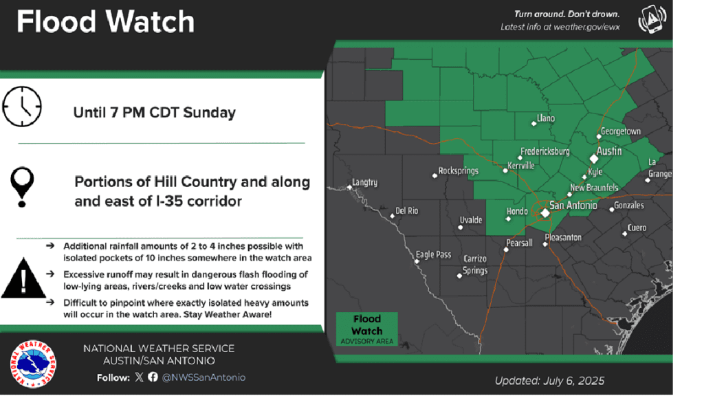
With the rain falling on soils that are still very wet from recent rains, this additional rain will quickly runoff and could cause flash flooding. The National Weather Service has posted a Flood Watch for all of the Hill Country and the Intestate 35 corridor, from Temple to San Antonio, (including the Austin metro) through 7 pm Sunday.
In general, additional rain amounts Sunday afternoon through Sunday night across the Hill Country and Central Texas regions are forecast to average between 2 and 4 inches, with isolated totals of 5-7 inches possible. Totals across the coastal plains are forecast to average around a half inch.
The outlook for Monday and Tuesday calls for a slight chance for scattered afternoon showers and thunderstorms across the entire region. Rain amounts are forecast to average around a quarter inch or less. Mostly sunny and dry weather is predicted for Wednesday through Friday.
Watching the Northern Gulf
National Hurricane Center forecasters indicate a trough of low pressure is likely to form near the southeastern
U.S. coast during the next day or two and then move westward across Florida into the northeastern Gulf by Tuesday. Environmental conditions could support some gradual development of this system during the middle to late part of this week while it moves westward over the northeastern and north-central portions of the Gulf. There is some probabilities in the various ensemble guidance suggesting slow development, but where any actual surface low may form is uncertain. This is something that definitely needs to be watched closely over the next several days.
The National Hurricane Center is currently giving this disturbance a 20 percent chance for tropical development over the next seven days.
Bob
Showers and Thunderstorms Returning for the Weekend. Pockets of Heavy Rain Possible
While it would appear our typical summertime weather pattern is trying to take hold, a chance for rain and thunderstorms will return to the forecast for Saturday and Sunday. Friday’s weather maps showed Texas being situated between ridges of high pressure centered over northwestern Mexico and just off the southeastern U.S. coast. A clockwise flow around the southeastern U.S. ridge is bringing moisture into the eastern half of the state. This weekend, a trough of low pressure dropping south into the southern Plains is expected to draw considerable moisture northwestward across Central Texas, the Hill Country and into West Texas. The weekend atmospheric setup appears favorable for the development of numerous rain showers and thunderstorms beginning in West Texas late Saturday, with the activity spreading southeast into the northern half of the Hill Country on Sunday. At the same time, scattered showers and thunderstorms are forecast to develop across the coastal plains region, with this activity expected to move northwest into parts of Central Texas. A dry and more summer-like pattern is forecast to take shape next week as the eastern ridge of high pressure spreads over Texas.
For Friday and Friday Night
Mostly sunny and dry weather is predicted for the Hill Country and Central Texas regions. For areas along and south of Interstate 10, there will be a 30 percent chance for scattered showers and thunderstorms. These rains should diminish around sunset. Totals should only average around a quarter inch. High temperatures are forecast to generally be in the low to mid-90s.
For Saturday
Across the Hill Country, forecasts call for a 30 percent chance for scattered showers and thunderstorms Saturday afternoon, with a 40-50 percent chance for showers and thunderstorms Saturday evening and Saturday night. Rain amounts through sunrise Sunday are forecast to average between 0.25 and 0.5 inches, with a few isolated heavier totals.
Across Central Texas, forecasts call for a 30-40 percent chance for scattered rain showers and thunderstorms Saturday afternoon and evening, with just a slight chance for rain after midnight Saturday night. Rain amounts through sunrise Sunday are forecast to average between 0.25 and 0.5 inches.
For the middle Texas coast, forecasts call for a 70 percent chance for showers and scattered thunderstorms Saturday morning through Saturday afternoon. The chance for rain looks to diminish Saturday evening. Totals through sunrise Sunday are forecast to around a half inch, with isolated higher totals.
High temperatures Saturday are predicted to be upper 80s to low 90.
For Sunday
A fairly widespread area of rain and thunderstorms is forecast to develop across West Texas early Sunday. Forecasts call for this activity to spread southeast into northern and western counties of the Hill Country Sunday morning through Sunday afternoon. Some of this rain could be locally heavy. Elsewhere, scattered showers and thunderstorms are forecast to increase in coverage Sunday afternoon.
For the Hill Country, there will be a 50 percent chance for showers and thunderstorms Sunday into Sunday evening. Rain amounts through sunrise Monday are forecast to average between 0.5 and 1 inch across the northern half, and be around a half inch across the southern half. Just a slight chance for rain is predicted for Sunday night.
Across Central Texas, there will be a 40-50 percent chance for scattered rain showers and thunderstorms Sunday afternoon into Sunday evening. Rain amounts through sunrise Monday are forecast to average between 0.25 and 0.5 inches.
For the middle Texas coast, there will be a 50-60 percent chance for showers and thunderstorms Sunday afternoon and Sunday evening. The rain should diminish late Sunday evening. Rain amounts through sunrise Monday are forecast to average between 0.25 and 0.5 inches
High temperatures Sunday are forecast to be in the low 90s.
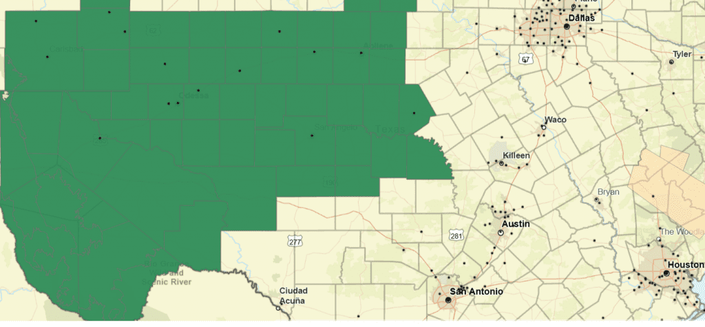
The National Weather Service has posted a Flood Watch for the northern Hill Country, the Concho Valley and all of West Texas from Saturday afternoon through Sunday afternoon. Parts of this area could see cumulative totals of 2 to 5 inches Saturday Night through Sunday. Isolated totals over 8 inches will be possible. With soils already still wet from recent rains, additional rain will quickly runoff, and possibly lead to flash flooding.
Flood Watch Saturday Afternoon through Sunday Afternoon for the Counties Highlighted in Green:
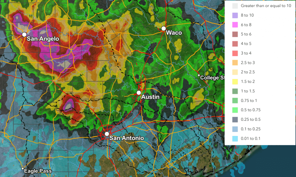
National Weather Service Rainfall Forecast Valid through 7 am Monday:
For Monday
There will be a 30 percent chance for afternoon showers and thunderstorms across the coastal plains region. Mostly sunny and dry weather is predicted for the rest of the region. High temperatures are forecast to be in the low and mid-90s.
Next Tuesday through Friday
Mostly sunny, dry, and warm weather is forecast across the entire region. Daily high temperatures are predicted to be in the mid-90s. Similar conditions are forecast into next weekend.
Tropicl Weather Outlook
Weather conditions are currently quiet across the tropical Atlantic and tropical cyclone development is not forecast for at least the next seven days.
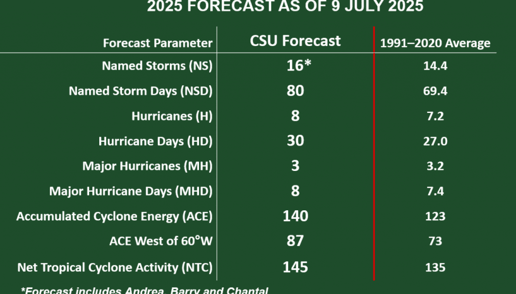
Klotzbach/CSU Team Lower Hurricane Numbers Slightly
On Wednesday, Phil Klotzbach and his forecast team at Colorado State University issued their July update for this year’s hurricane season. The updated outlook lowered the projected number of named storms slightly, from 17 to 16. The outlook calls for 8 hurricanes, with the possibility of 3 major hurricanes.
According to Dr. Klotzbach, the reason for the slight decrease in numbers is due to an observed southwest to northeast area of wind shear that is occurring across the Caribbean Sea. This belt of wind shear is forecast to continue at least trough August. Wind shear tends to dissipate developing and active storms. As of now, it’s unclear if this wind shear will continue through September and October.
Have a great weekend!
Bob
Scattered Showers Expected Wednesday and Again this Weekend
As of late Wednesday morning. Doppler radar was showing the development of showers and isolated thunderstorms across the eastern Hill Country, including Burnet and Llano Counties. Other showers were developing across Central Texas and the middle Texas coast. LCRA’s Hydromet gauge located at Smithville, in Bastrop County, recorded 0.35 inches in 15 minutes from one of these passing showers around 11 am.
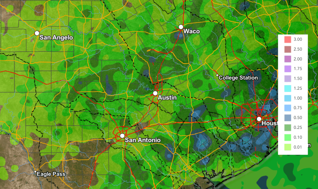
We’ll be looking at a 40-50 percent chance for more scattered rain showers and thunderstorms across the entire region Wednesday afternoon into Wednesday evening. This chance for rain will includes the Kerr County area. A trough of low pressure sinking south out of North Texas along with abundant moisture flowing north from the Gulf is expected to help in the development the rain. Today’s rain is not expected to be as focused nor as heavy as we saw over the holiday weekend. However, a few isolated heavy downpours will be possible. In general, most totals should average under a half inch, but some isolated totals of 1-2 inches will be possible. Totals are forecast to be a little higher across the coastal plains region. With area soils still very wet from recent rains, this additional rain will runoff quickly. Today’s activity is expected to diminish around sunset as temperatures begin to cool.
NWS Rainfall Forecast Valid through 7 am Thursday:
The outlook for Thursday and Friday calls for sunny and dry weather as some drier air works into the area. High temperatures are predicted to be in the upper 80s to low 90s. There will be a 30 percent chance for scattered rain showers across the coastal region on Friday.
A chance for scattered rain showers and thunderstorms will return to the forecast this weekend, continuing into Monday as an enhanced area of moisture is drawn into Texas off the Gulf. Forecasts call for a 40-50 percent chance for afternoon and evening rain showers across the region on both days. Heavy rain is not expected. Rain amounts each day are forecast to average close to a quarter inch, with isolated totals to near 1 inch possible. High temperatures will continue to be mostly in the low 90s.
Bob
A Potential for More Heavy Rain Sunday
The weak area of low pressure largely responsible for all of the heavy rain across the Hill Country and Central Texas the past few days was centered Sunday morning over north Central Texas. A trough of low pressure in the middle atmosphere stretches southwest from the low, out to near Junction. Across the Hill Country and Central Texas, the atmosphere remains unusually moist and modestly unstable. As temperatures warm Sunday afternoon, rain shower and thunderstorm development is forecast to take place mainly along and to the west of the Interstate 35 corridor. The showers that do develop are predicted to be slow-movers and will have the potential to produce large amounts of rain in short periods of time. Showers and scattered thunderstorms can be expected Sunday afternoon through Sunday evening, with the probability for rain being near 50 percent.
High resolution forecast show potential rain amounts through Sunday afternoon through Sunday evening to be between 1 and 3 inches, with isolated totals to near 7 inches possible. For areas east of Interstate 35, totals through Sunday evening are forecast to remain below a quarter inch.
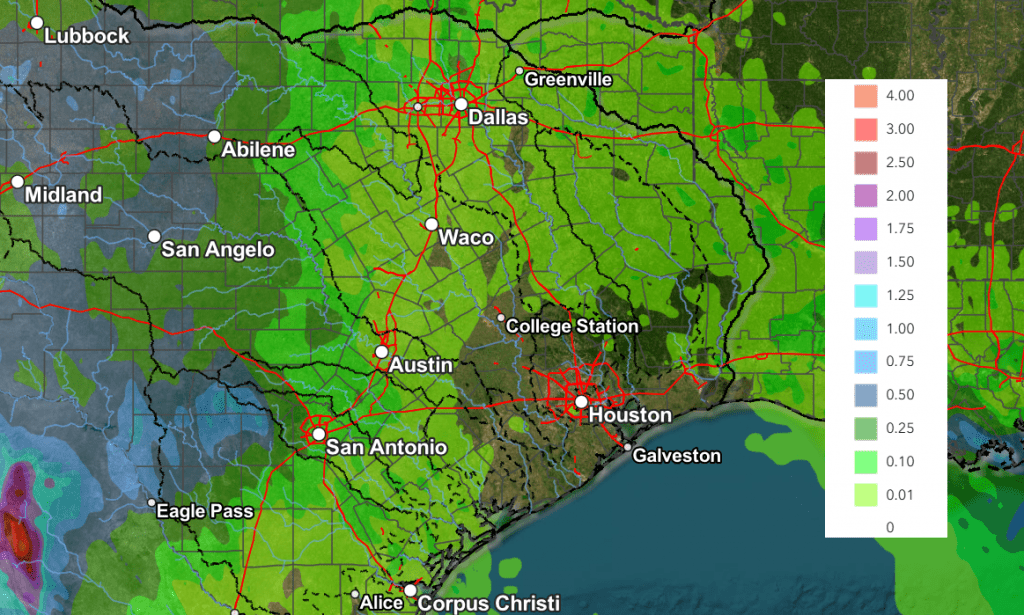
NWS Rainfall Forecast Valid through 7 am Monday:
With area soils currently wet and saturated from recent rains, any additional rain Sunday afternoon will quickly runoff and aggravate ongoing flooding and fast-moving streams. Due to the threat for considerable runoff, the National Weather Service has posted a Flood Watch for the Hill Country and the Austin/Interstate 35 corridor through 7 pm Sunday.
Little rain is forecast across the region Sunday night as the remnant low pressure area finally moves away.
For Monday, there will be a 30 percent chance for scattered showers and thunderstorms for areas along and west of I-35 due to lingering moisture. However, the rain is not expected to be as intense of as focused as we’ve seen over the past few days. Rain amounts are forecast to average less than a half inch.
There will be a 30-40 percent chance for more scattered showers and thunderstorms across the entire region Tuesday and Wednesday as an enhanced area of tropical moisture spreads inland from the Gulf. However, heavy rain is not expected. Totals each day are forecast to only average around a quarter inch, or less.
Generally dry and sunny weather is forecast Thursday and Friday, continuing into next weekend as a summer pattern finally returns to the area. The temperature will trend warmer, with highs in the mid and upper 90s.
Bob
Showers With Possible Heavy Rain will Continue through Friday Evening
An area of low pressure over West Texas (part of the remnants of Tropical Storm Barry) and an unusually moist atmosphere caused the development of heavy to very heavy rain across parts of the Hill Country Thursday night into Friday morning. Some of the highest totals of rain fell over the area between San Angelo, Mason, and San Saba, and also over western Kerr County where totals between 4 and over 12 inches of rain were observed. One of the highest rain totals recorded occurred in northwestern Mason County, where an LCRA Hydromet gauge has recorded a 24-hour total of 15.56 inches( as of 11:30 am). Here’s a view of the estimated rain falling over the past 24 hours:
NWS Estimate of rain falling between 7 am Thursday and 7 am Friday:
Data courtesy of the NWS West Gulf River Forecast Center
As of late Friday morning, satellite images showed the area of low pressure was still centered over the northern Hill Country. Satellite and radar imagery clearly shows a cyclonic circulation associated with the area of low pressure, but this is not a tropical cyclone. High resolution forecasts call for the area of low pressure to remain somewhat stationary this afternoon, then weaken and slowly drift to the south late Friday afternoon into Friday night. Meanwhile, an unusually moist atmosphere remains in place across the region and atmospheric conditions remain favorable for the development of more moderate to heavy rain across the Hill Country and parts of Central Texas (including the Austin area) this afternoon into this evening. The probability for rain will be near 100 percent across the Hill Country, 50 percent along the I-35 corridor, and near 30 percent at most other locations. The chance for rain is expected to decrease to around 30 percent overnight Friday night.
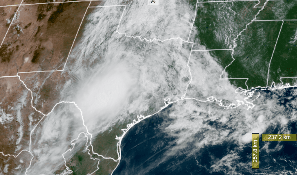
NOAA/Colorado State University/RAMMB 07/04/2025 11:10 am CDT
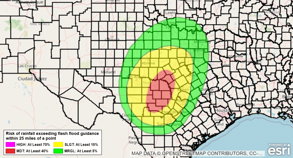
The Weather Prediction Center has outlooked the Hill Country region, from Brownwood to Kerrville, with a moderate risk for excessive rainfall this afternoon through 7 am Saturday. Surrounding the moderate risk area, a slight chance for excessive rain covers the Austin/Intestate 35 corridor and the western Hill Country.
Rain forecasts show a potential for an additional 1-3 inches of rain across the Hill Country and the Austin/I-35 corridor through Friday night. Isolated totals to near 5 inches will be possible.
The outlook for Saturday calls for a much smaller coverage of rain across the area as the low weakens and a ridge of high pressure over Arizona begins to spread over Texas. Expect a 30 percent chance for rain and thunderstorms cross the Hill Country and the I-35 corridor. Rain amounts should average less than a half inch.
The outlook for Sunday calls for generally sunny and dry weather, with just a couple of isolated rain showers and thunderstorms.
Have a safe and happy Fourth of July and holiday weekend!
Bob
Dry and Hot Weather for Independence Day Weekend and Next Week
The circulation around a trough of low pressure across the western U.S. and a broad ridge of high pressure over the lower Mississippi Valley region is helping to funnel remnant moisture from Tropical Storm Barry and abundant Gulf moisture north across the western half of Texas. This moisture, combined with weak atmospheric lift, has resulted in the development of showers and scattered thunderstorms across West Texas, the Hill Country, and parts of Central Texas over the past couple of days. The wet and unsettled pattern is forecast to continue through Thursday night. Showers are forecast to diminish across most of our region Friday as a drier and more stable atmosphere spreads in from the east.
For Wednesday and Wednesday Night
Scattered showers and thunderstorms are forecast for areas mainly along and west of Interstate 35 Wednesday afternoon into Wednesday evening as waves of tropical moisture spread to the north. The probability for rain will be near 50 percent across the Hill Country and near 20 percent at most other locations. The chance for rain is expected to diminish across Central Texas and the middle Texas coast after sunset Wednesday evening. Across the Hill Country, there will be a 30 percent chance for scattered rain showers and thunderstorms Wednesday evening, continuing through Wednesday night.
Rain amounts through sunrise Thursday are forecast to generally average around a half inch across the Hill Country. Isolated totals of 1-2 inches will be possible with some of the heavier downpours. Elsewhere, totals should generally average less than a quarter inch.
- High temperatures Wednesday will include the mid and upper 80s across the Hill Country, the mid-90s across Central Texas, and the low 90s across the coastal plains
For Thursday and Thursday Night
Forecasts call for another good chance for rain showers and scattered thunderstorms across the Hill Country, with the probability for rain remaining near 50 percent. There will be a 40 percent chance for additional showers and thunderstorms Thursday evening and Thursday night.
Meanwhile, a somewhat better chance for rain showers and thunderstorms is forecast for Central Texas compared to Wednesday, as the moisture plume is expected to bend further to the east. The probability for rain will be near 30-40 percent. Across the coastal plains, the probability for rain looks to remain near 20 percent.
Rain amounts Thursday through sunrise Friday are forecast to generally average around a half inch, with isolated higher totals. Across Central Texas, totals are forecast to average between a quarter and a half inch. Across the coastal plains, totals should average less than a quarter inch.
- High temperatures Thursday are predicted to be in the mid and upper 80s across the Hill Country, and in the low 90s at most other location
For Independence Day and Friday Night
A slight chance for rain showers and thunderstorms is forecast across the Hill Country, Central Texas, and coastal regions, with the probability s being near 20 percent.
- High temperatures are forecast to be near 90 degrees across the Hill Country, in the mid-90s across Central Texas, and in the low 90s across the coastal plains
NWS Rainfall Forecast Valid through 7 pm Friday:
Weekend Weather
Mostly sunny, warmer, and rain-free weather is forecast across the region as the ridge of high pressure spreads across Texas from the east.
- High temperatures are forecast to be in the low 90s across the Hill Country, with mid-90s across Central Texas and the coastal plains
Next Week
Mostly sunny, dry, and hot weather is forecast for next week as the subtropical ridge of high pressure (or heat dome) sets up over northern Mexico and the Desert Southwest. Temperatures will likely trend warmer throughout the week, with triple-digit readings possible by mid-week.
- High temperatures Monday and Tuesday are forecast to be in the mid-90s across the Hill Country, the mid and upper 90s across Central Texas, and mid-90s across the coastal plains
- High temperatures Wednesday through Friday are predicted to be in the mid to upper 90s across the Hill Country, near 100/101 degrees across Central Texas, and in the middle 90s towards the coast
The outlook for next weekend calls for continued dry weather with little change in the temperature.
Tropical Weather Outlook
Weather conditions across the Gulf, the Caribbean Sea and the tropical Atlantic are currently very quiet.
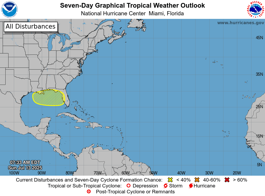
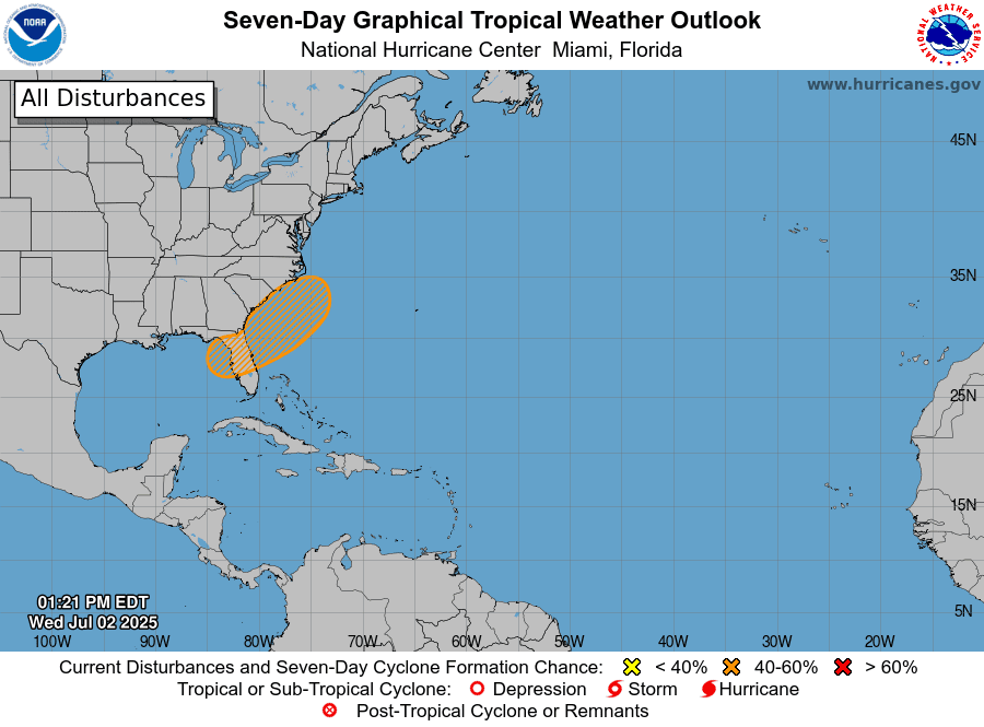
National Hurricane Center forecasters are monitoring the southeastern U.S. Atlantic and eastern Gulf coasts where an an area of low pressure could develop by this weekend along a stalled boundary. Environmental conditions appear only marginally conducive for some slow development, but its possible a tropical or subtropical depression could form in this region over the weekend or early next week. Should a system develop, it is expected drift northward or northeastward, away from Texas.
NHC forecasters are giving this area a medium, or 40 percent, chance for tropical development over the next seven days.
NOAA/Colorado State University/RAMMB 07/02/2025 3:10 pm CDT
More Saharan Dust Expected Next Week
Another plume of light to moderately dense Saharan dust is forecast to arrive over South Texas Friday and spread inland to cover most of the state this weekend. Satellite images show this to be a rather large plume and it is expected to affect Central and South Texas through at least the middle of next week. It will likely cause a milky white sky and lower visibility.
Wishing everyone a safe and happy Independence Day and holiday weekend!
Bob
Social Media