Keeping an Eye on the Northwestern Gulf. Showers and Thunderstorms Expected through the Weekend
AUG. 30, 2024
The National Hurricane Center’s Friday midday update is now highlighting an area of unsettled weather located off the upper Texas coast that has a low potential to develop into a tropical cyclone.
NHC forecasters note a surface trough of low pressure, a reflection of the broad area of low pressure in the upper atmosphere over the northwestern Gulf of Mexico, has taken shape over the past few hours. Both features are producing a large area of disorganized showers and thunderstorms along and just offshore of the upper Texas and Louisiana coasts.
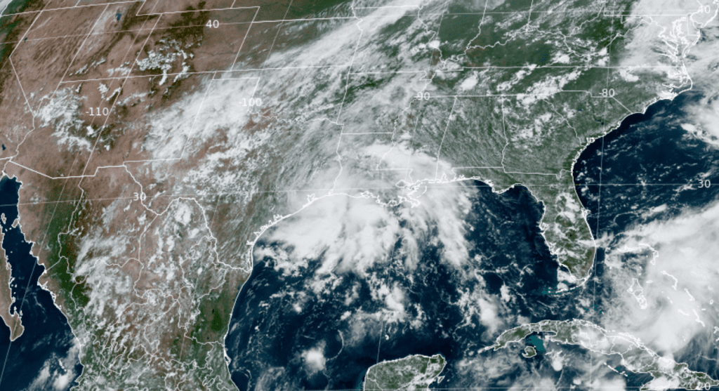
NOAA/Colorado State University/RAMMB 08-30-24 1:10 pm CDT
According to the National Hurricane Center, this system is expected to meander near the upper Texas coast over the weekend and through much of next week. Some slow tropical development will be possible if the system can stay offshore. Regardless of development, the system is expected to bring heavy rains to portions of coastal Louisiana and the upper Texas coast during the next few days.
The NHC is currently giving this system a low chance, a 10 percent chance, for tropical development over the next two days, and a 20 percent chance for tropical development over the next seven days.
While I’m not expecting any significant development of this system this weekend, I urge everyone to keep up with additional updates from the National Hurricane Center.
Weather Discussion
A moist and somewhat unsettled weather pattern is in place as we head into the holiday weekend. While conditions appear favorable for periods of rain and scattered thunderstorms over the weekend, a total washout is certainly not anticipated. Not everyone will see rain on each day. For those planning outdoor activities, be prepared for some scattered shower and thunderstorm interruptions, followed by periods of dry weather. Rain totals through Monday are forecast to be highest across the coastal plains and Edwards Plateau regions, and lowest across Central Texas and the eastern Hill Country.
Friday’s weather maps showed an interesting weather set up for late August. A broad, non-tropical area of low pressure was located over the northwestern Gulf of Mexico while another area of low pressure was located across southeastern New Mexico. Between the two systems, a moist and slightly unstable atmosphere is in place. Fortunately, the heat dome is nowhere to be found at the current time. Forecasts call for the low over the northwestern Gulf to remain nearly stationary through Labor Day. The circulation around the low will maintain a moist flow of tropical moisture from the coast, northwest to Central Texas and the Hill Country. The abundant tropical moisture and warming afternoon temperatures will be a source for scattered showers and thunderstorms. Meanwhile, the low over southeastern New Mexico is forecast to track to the east this weekend, helping to push a rare, weak cold front southeast through the Hill Country and eventually into Central Texas. The upper trough and cold front will both help spark the development of showers and thunderstorms across the region—mainly Sunday through Tuesday.
Breaking the outlook down day-by day:
Friday afternoon and Friday night
Expect a partly cloudy sky across the region. There will be a 30 percent chance for scattered rain showers and thunderstorms across the Hill Country and Central Texas regions and a 40 percent chance for showers and thunderstorms across the coastal plains. Across the Edwards Plateau and western Hill Country, the probability for late afternoon and evening showers and thunderstorms will be near 50 percent as the cold front slowly sinks to the southeast. Most of the rain activity should diminish by late evening.
For areas that do happen to see rain, totals should average less than a quarter inch, with isolated totals to around 1 inch possible.
High temperatures are forecast to be in the low to mid-90s.
Saturday through Saturday Night
Expect a partly cloudy sky across the region. The most favorable area for rain looks to be across the western half of the Hill Country and locations to the south of Interstate 10. Here, the probability for rain is forecast to be near 50-60 percent Saturday through Saturday evening. For the Austin and Central Texas regions, the probability for showers and thunderstorms in the afternoon and evening is forecast to be near 40 percent.
For areas that see rain, totals are forecast to average close to a quarter inch, with isolated totals to near 1.5 inches possible.
High temperatures Saturday are forecast to be near 90-92 degrees.
Sunday through Labor Day
The probability for rain showers and thunderstorms is forecast to increase to near 70 percent across the region as the cold front stalls over Central Texas and coastal low drifts a bit further to the west. The most favorable period for rain looks to be in the afternoon and evening hours. A higher coverage of rain is anticipated, compared to Friday and Saturday.
Rain amounts each day are forecast to average between a quarter and a half inch, with isolated totals of 1-2 inches possible.
Expect a partly to mostly cloudy sky both days, with high temperatures around 88-90 degrees.
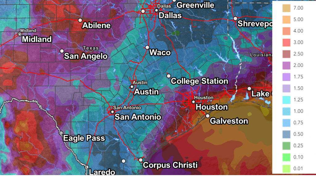
Total Rainfall
Rain amounts between Friday afternoon and next Wednesday morning are forecast to average between 1 and 2 inches across the western Hill Country, and between 2 and 5 inches across Wharton and Matagorda Counties. For most of the Hill Country and Central Texas, totals are forecast to average close to 1 inch.
NWS Rainfall Forecast for the Period 7 pm Friday through 7 pm Wednesday:
Outlook for Next Tuesday through Friday
Forecasts indicate the wet and unsettled pattern will continue as a broad trough of low pressure begins to setup across the central U.S. The most favorable days for rain are expected to be Tuesday and Wednesday, where the chance for rain will remain around 50-60 percent. The chance for rain will lower to 30-40 percent next Thursday and Friday. Rain amounts Tuesday through Friday are forecast to average around a half inch to 1 inch, with isolated heavier totals.
High temperatures next Tuesday through Friday are forecast to generally be in the low 90s.
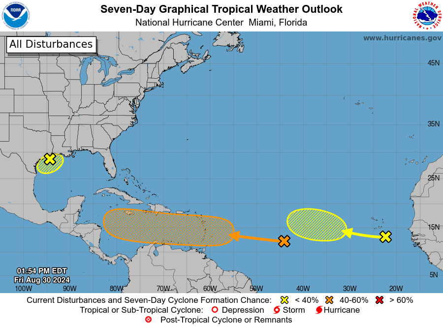
Tropical Weather Outlook
The National Hurricane Center is keeping an eye on two potential systems located in the central and eastern tropical Atlantic, but neither system poses a threat to the Gulf of Mexico through the holiday weekend.
Across the central tropical Atlantic, forecasters are monitoring a broad area of disorganized showers and thunderstorms associated with a tropical wave. Gradual development of this system will be possible during the next few days, and a tropical depression could form sometime next week as the system moves to the west. It is predicted to reach the Lesser Antilles Monday and continue moving west across the Caribbean Sea through the middle to latter part of the week.
NHC forecasters are giving this system a medium, or 40 percent chance, for tropical development over the next seven days.
Another tropical wave was located between the west coast of Africa and the Cabo Verde Islands. This system is currently producing minimal shower and thunderstorm activity. However, some slow development of this system will be possible through late next week as the wave continues to move slowly to the west-northwest.
NHC forecasters are currently giving this system a low, 20 percent chance, for tropical development over the next seven days.
Wishing everyone a safe and enjoyable holiday weekend as we close out the summer season.
Bob
Social Media