Hot, Summer-Like Weather Forecast for the Next Week
SEPT. 13, 2024
We’re closing out the workweek with dry and quiet weather conditions thanks to an August-like heat dome/ridge of high pressure spreading to the east out of northern Mexico. Forecasts call for the heat dome to become centered across Texas early next week and remain over the area through late in the week. With the heat dome in place, hot temperatures and little to no rain will be the primary weather stories for this weekend and all of next week.
While the temperature for the first twelve days of September has been somewhat tolerable, August-like heat and humidity looks to be making a return visit Friday afternoon, continuing through the weekend, and early next week. The temperature could possibly reach triple digits at a few Hill Country and Central Texas locations. A sunny to mostly sunny sky will be in place through the period. Light southerly winds are forecast—mainly in the range of 5 to 10 mph.
- High temperatures Friday through Monday are forecast to be near 97-100 degrees across the Hill Country and Central Texas regions, and be in the mid-90s across the coastal plains
While our region will be under the influence of the heat dome this weekend, some of the high resolution forecasts call for a small wave of low pressure to spread east out of northern Mexico on Saturday. Increasing moisture ahead of this wave may help to generate an isolated rain shower or thunderstorm across parts of the Interstate 35 corridor Saturday afternoon. Due to the stable presence of the heat dome, the chance for rain will be below 20 percent. Again, a very low probability for any rain.
Sunny and hot weather will continue Tuesday through Friday as the heat dome remains over Texas. Forecasts show daily high temperature coming down a couple of degrees as the heat dome weakens slightly.
- High temperatures Tuesday through Friday are forecast to be in the mid-90s across the Hill Country and Central Texas regions, and in the low 90s across the coastal plains
Looking out a little further into next weekend and the week of September 23rd, little change is forecast. The heat dome over Texas is predicted to shift back more to the west. With less influence from the heat dome, it should open the door for moisture and a few widely scattered rain showers to spread north from the Gulf. However, no widespread or heavy rain is likely. High temperatures are forecast to generally be in the low to mid-90s.
Tropical Weather Outlook
The remnants of Francine are currently spreading north across the middle Mississippi and Tennessee Valley regions.
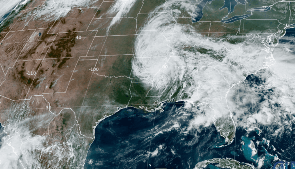
NOAA/Colorado State University/RAMMB 09/13/24 1:50 pm CDT
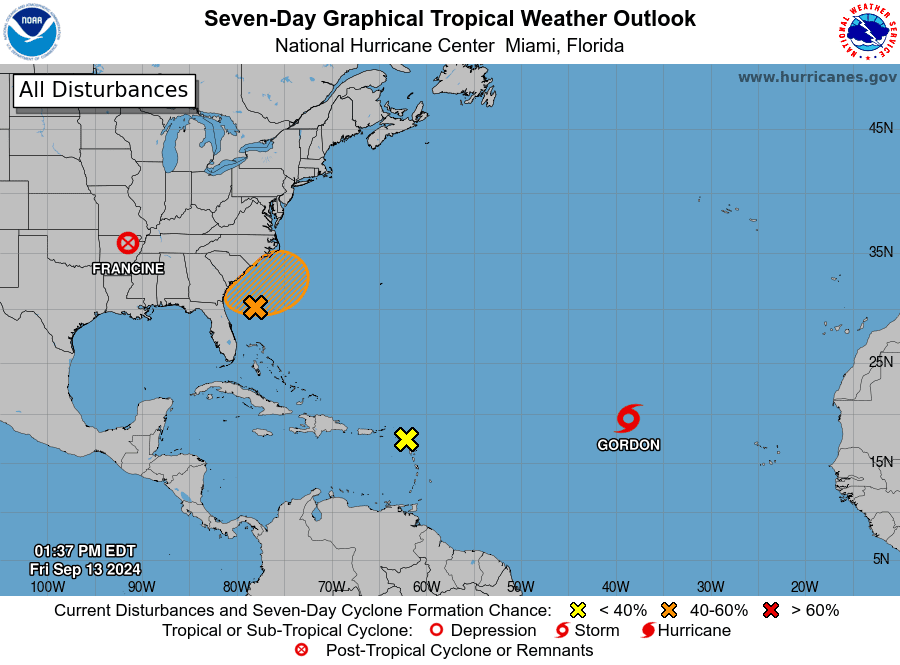
Out in the central tropical Atlantic, Tropical Storm Gordon has developed, with top winds of 40 mph.. Gordon is forecast to continue moving to the west through the weekend and weaken slightly. Gordon is predicted to eventually turn to the north over the open Atlantic.
NHC forecasters are monitoring a tropical wave located over the northern Leeward Islands. Environmental conditions don’t appear favorable for development through the weekend. Forecasters are also watching the area off the coast of the southeastern U.S., where a non-tropical low pressure area could form along a frontal boundary over the weekend. The low may develop some subtropical or tropical characteristics, and a subtropical or tropical depression could form early next week while the system moves generally northwestward toward the coast.
Neither of these two systems pose a threat to the Gulf of Mexico.
Elsewhere, weather conditions are quiet and tropical cyclone development is not expected over the next 5-7 days.
Have a great weekend!
Bob
Social Media