Key Points
- Hurricane and Tropical Storm Watches will likely be issued for portions of the Texas coast later today.
- Residents along the Texas coast are urged to closely monitor the progress of Beryl and have hurricane plans in place.
- Beryl is forecast to make landfall as a category 1 hurricane close to Brownsville Sunday night.
- The greatest risk for tropical storm force winds will be across the lower and middle Texas coast.
- The NHC forecasts Beryl will continue moving inland Monday, with its path trending more to the north. The remnant tropical storm/tropical depression is forecast to track north into Central Texas Tuesday and Tuesday night.
- Confidence for widespread rain has increased across the Hill Country, Central Texas, and the middle Texas coast has increased for the early and middle parts of next week, with rain chances possibly continuing through late week.
- Impacts for areas along and east of Interstate 35 may include heavy rain, gusty winds, along with some isolated tornadoes associated with the system’s rain bands.
Discussion
The center of Hurricane Beryl made landfall on the Yucatan Peninsula of Mexico, just northeast of Tulum at about 6 am CDT Friday. As of early Friday afternoon, Beryl had weakened to a tropical storm with maximum sustained winds of 65 mph. The center was located about 65 miles east-southeast of Progreso, Mexico.. Continued weakening is expected today as Beryl crosses the Yucatan Peninsula. However, slow re-intensification is expected once Beryl moves back over the Gulf of Mexico Friday night.
For the next 24 hours or so, Beryl will be steered generally west-northwestward across the southern Gulf of Mexico by a ridge of high pressure over the southeastern U.S. After that, a turn more to the northwest is expected as the storm moves to a break in the heat ridge situated over the central U.S. On this northwestward path, NHC forecasters call for the center of Beryl to reach the western Gulf sometime Sunday afternoon. While the forecast track guidance has come into better agreement, there is still uncertainty based on the possible strength and vertical depth of Beryl. The majority of the latest forecast model guidance is now favoring a more northward motion compared to previous forecasts. Based on this, the new official forecast has also been nudged a little more to the north, or to the right of the previous forecast. Additional adjustments of the forecast track could be necessary later today.
Track
Post landfall, Beryl is forecast to move into the weakness between the ridges, turning to the north and possibly north-northeast across south-central and central Texas. According to the latest NHC forecast track, the center of Beryl is forecast to spread across Central Texas as a weakening tropical storm Tuesday into Tuesday night. The key to our region’s weather for the first half of next week will hinge on how much Beryl turns to the right. There’s some chance Beryl’s path could bend even more to the right, depending on the location and magnitude of the break in the ridges. This would then take the center into Southeast, rather than Central Texas.
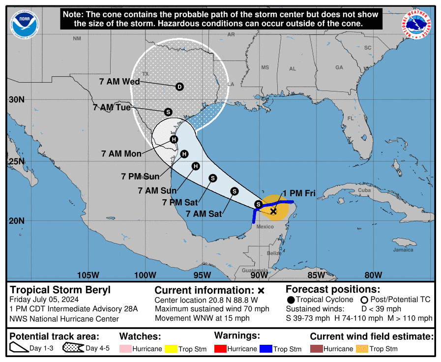
Do note the entire region is in the track cone of uncertainty for days 4 and 5 (Tuesday and Wednesday).
Forecast/Impacts
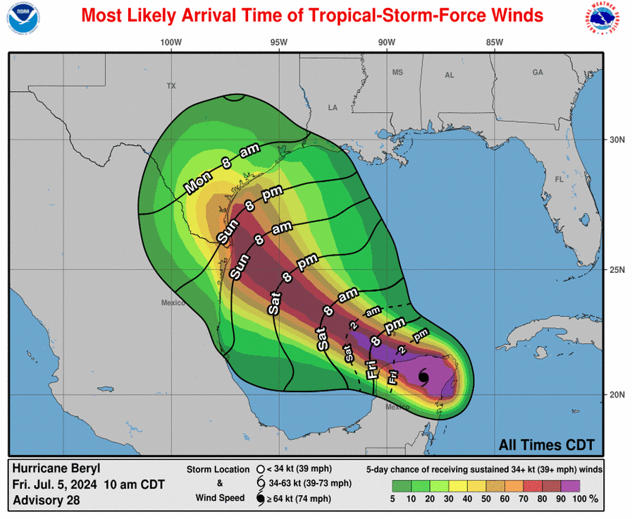
Significant impacts for wind, storm surge, and heavy rain will be working northward along the lower to middle Texas coastal regions Sunday night into Monday morning. Tropical storm force winds are forecast to arrive along the lower Texas coast Sunday evening, then spread northward to middle Texas coast Monday morning. Hurricane conditions will be likely along the lower Texas coast Sunday night into Monday, with the impacts possibly extending as far north as Kingsville and Corpus Christi. Depending on the exact path of Beryl, strong winds to tropical storm strength may be felt across parts of the Austin and Central Texas area Tuesday into Tuesday night.
Rain is forecast to increase across the region Monday as considerable moisture is pulled inland. The heaviest rains are predicted to fall near and east of the storm’s center. As of now, that means areas along and to the east of Intestate 35. Overall, confidence in rain amounts is low, depending on the path of the system once inland. Widespread rain and thunderstorms are forecast across the region Tuesday into Wednesday. Additional rain will likely continue on Thursday.
Do note some isolated tornadoes associated with the system’s rain bands will be possible Tuesday for areas east of I-35 Tuesday.
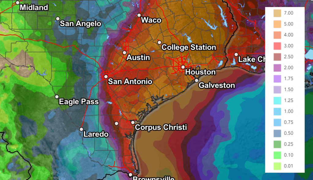
The Weather Prediction Center’s 7-day rainfall forecast issued midday Friday and valid through 7 pm next Friday, calls for widespread totals of 3-5 inches for locations along and east of Interstate 35 (including the Austin metro). Totals of 1-2 inches are forecast for the eastern Hill Country, with 0.5-1 inch totals for the western half.
NWS Rainfall Forecast for the Period 7 pm Friday through 7 pm Next Friday:
I urge everyone to keep up with the latest forecast from the National Hurricane Center and the National Weather Service as we move through the weekend.
Bob
Social Media