Rain showers and thunderstorms spread across the Hill Country and the Interstate 35 corridor over the weekend. A few of the storms produced damaging winds and some small hail. Rainfall generally averaged around a half inch, with several isolated totals just over an inch. Southeast of Austin, totals between Bastrop and Bay City were considerably lower, averaging around a tenth of an inch or less. It’s interesting to note an area of heavy, persistent rain developed across the northern counties of Southeast Texas late Sunday night. Totals of 7 to near 12 inches of rain fell over the area between College Station, Huntsville, and Lake Livingston.
NWS Estimate of Rain Falling Between 7 am Friday and 7 am Monday:
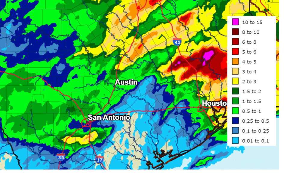
Map Courtesy NOAA’s West Gulf River Forecast Center
A break from the wet and unsettled weather pattern is forecast to take place Monday afternoon through Tuesday evening as a weak ridge of high pressure temporarily sets up across Texas. Southeasterly breezes off the Gulf of Mexico are pulling a very moist air mass inland from the Gulf of Mexico, and this is leading to warm and very humid weather conditions. Expect a mostly sunny sky Monday afternoon. Low clouds look to spread across the area Monday night into Tuesday morning. In fact, some patchy will also be possible. The sky should become mostly sunny Tuesday afternoon.
- Monday’s temperature is predicted to reach the mid and upper 80s.
- Lows Tuesday morning are forecast to be in the mid and upper 60s.
- High temperatures Tuesday are forecast to be in the upper 80s to 90 degrees.
- Lows Wednesday morning are predicted to be around 70-72 degrees.
A chance for scattered afternoon and evening rain showers and thunderstorms will return to the forecast Wednesday when a small trough of low pressure is forecast to push east out of Far West Texas. This system is expected to cause thunderstorm development along the dry line across West Texas Wednesday afternoon. These developing thunderstorms are forecast to spread east across the Edwards Plateau and Hill Country regions late Wednesday afternoon through Wednesday evening. Some of these thunderstorms may be strong to severe, capable of producing large hail and damaging winds. The probability for rain and storms across the Hill Country will be near 40 percent late Wednesday afternoon and evening. At the same time, isolated to scattered rain showers and thunderstorms are also forecast to develop across Central Texas and the coastal plains region Wednesday afternoon and evening as the wave of low pressure moves over the area. The probability for rain will also be near 40 percent. Rain amounts Wednesday through Wednesday evening are predicted to average around a quarter inch or less. Wednesday’s temperature should climb to the low and mid-80s.
The most favorable period for rain showers and thunderstorms is expected to happen Thursday through Thursday night when a large trough of low pressure dips southeast into North Texas out of the southern Rockies. Forecasts call for an area of showers and thunderstorms to develop across the Concho Valley and Northwest Texas early Thursday afternoon. The area of rain and storms is expected to expand in coverage and intensity as it pushes east into Central Texas and the coastal plains regions late Thursday afternoon through Thursday night. Some of these storms may be strong to severe. The probability for rain will around 60-70 percent Thursday and Thursday night. The precipitation is forecast to exit to the east and southeast Friday morning as a cold front brings in drier and just slightly cooler air.
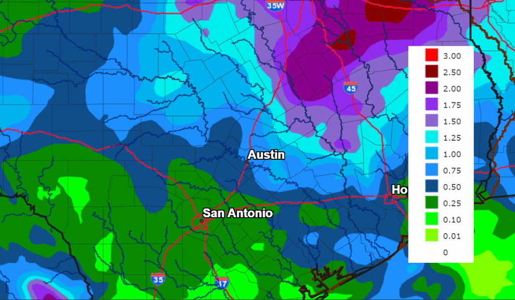
Rainfall forecasts through early Friday morning call for totals to generally average between 0.5 and 1 inch, with isolated totals to near 2 inches possible.
NWS Rainfall Forecast for the Period 7 pm Monday through 7 pm Friday:
Just a slight chance for rain is forecast Friday as the weak cold front pushes south into the Gulf of Mexico. Expect a partly cloudy sky with highs in the low 80s.
The outlook for the upcoming weekend calls for a partly cloudy sky and 30 percent chance for scattered afternoon and evening showers and thunderstorms both days. Rain amounts are forecast to average around a quarter inch. Warm and humid air looks to return in earnest this weekend. Expect high temperatures in the low and mid-80s, with lows in the upper 60s.
The outlook for next week calls for generally dry weather and noticeably warmer temperatures as a ridge of high pressure builds north across Texas. While a few showers can’t be ruled out, no widespread or heavy rain is anticipated. Daily high temperatures look to be around 90 degrees. Highs in the low 90s will be possible next Tuesday and Wednesday. Lows are forecast to be in the low 70s.
Bob
Social Media